Mirocin elevation
Mirocin (Subcarpathian, Powiat przeworski), Poland elevation is 205 meters and Mirocin elevation in feet is 673 ft above sea level [src 1]. Mirocin is a populated place (feature code) with elevation that is 14 meters (46 ft) bigger than average city elevation in Poland.
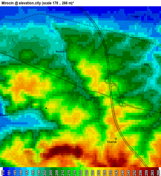
Below is the Elevation map of Mirocin, which displays elevation range with different colors. Scale of the first map is from 178 to 266 m (584 to 873 ft) with average elevation of 212.3 meters (=697 ft) [note 1]
These maps also provides idea of topography and contour of this city, they are displayed at different zoom levels. More info about maps, scale and edge coordinates you can find below images.
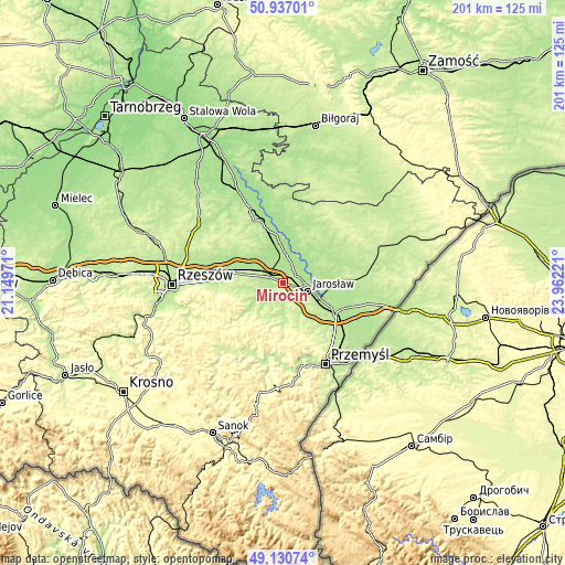
| \ | Map #1 | Topo.Map |
| Scale [m] | 178..266 m | × |
| Scale [ft] | 584..873 ft | × |
| Average | 212.3 m = 697 ft | × |
| Width | 6.28 km = 3.9 mi | 200.8 km = 124.8 mi |
| Height | 6.28 km = 3.9 mi | 200.8 km = 124.8 mi |
| ↑Max Latitude | 50.070584° | 50.93701° |
| Latitude at center | 50.04237° | 50.04237° |
| ↓Min Latitude | 50.014139° | 49.13074° |
| ← Min Longitude | 22.512015° | 21.14971° |
| Longitude center | 22.55596° | 22.55596° |
| →Max Longitude | 22.599905° | 23.96221° |
Nearby cities:
Cities around Mirocin sort by population:
• Przeworsk elevation 201 m
4.8 km,  292°
292°
• Rozbórz 203 m
1.7 km,  337°
337°
• Gorliczyna 179 m
7.4 km,  318°
318°
• Pawłosiów 208 m
8.4 km,  128°
128°
• Urzejowice 199 m
7.5 km,  243°
243°
• Zarzecze 201 m
6.4 km,  192°
192°
• Wólka Pełkińska 176 m
7.6 km,  39°
39°
• Żurawiczki 190 m
5.1 km,  231°
231°
• Dębów 199 m
8.6 km,  271°
271°
• Wierzbna 203 m
3.4 km,  107°
107°
• Zalesie 232 m
3.7 km,  206°
206°
• Jagiełła 178 m
5.9 km,  11°
11°
Multilingual:
 En español:
Mirocin elevación 205 m.
 En France:
Mirocin élévation 205 m.


Sources and notes:
- [note 1] Map square and city borders are not equal. Map elevation data is calculated only from area inside that square.
- [src 1] Elevation data from geonames database provided with same terms of usage.
- [src 2] The elevation map of Mirocin is generated using elevation data from NASA's 3 arcsec (90m) resolution SRTM data.
- [src 3] Base (background) map © OpenStreetMap contributors tiles are generated by Geofabrik and OpenTopoMap.
Copyright & License:
This Mirocin Elevation Map is licensed under CC BY-SA. You may reuse any part from this page, if you give a proper credit by linking to this URL:
 More info on terms of use page.