Zarzecze elevation
Zarzecze (Subcarpathian, Powiat przeworski), Poland elevation is 201 meters and Zarzecze elevation in feet is 659 ft above sea level [src 1]. Zarzecze is a seat of a third-order administrative division (feature code) with elevation that is 10 meters (33 ft) bigger than average city elevation in Poland.
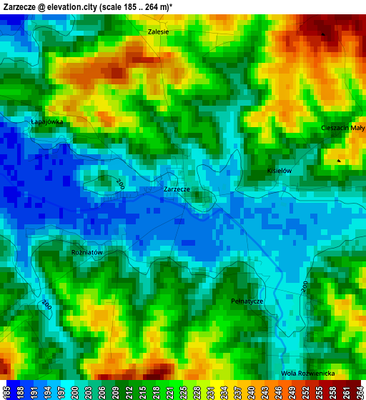
Below is the Elevation map of Zarzecze, which displays elevation range with different colors. Scale of the first map is from 185 to 264 m (607 to 866 ft) with average elevation of 213.4 meters (=700 ft) [note 1]
These maps also provides idea of topography and contour of this city, they are displayed at different zoom levels. More info about maps, scale and edge coordinates you can find below images.
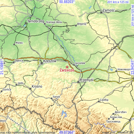
| \ | Map #1 | Topo.Map |
| Scale [m] | 185..264 m | × |
| Scale [ft] | 607..866 ft | × |
| Average | 213.4 m = 700 ft | × |
| Width | 6.28 km = 3.9 mi | 201.1 km = 125 mi |
| Height | 6.28 km = 3.9 mi | 201.1 km = 125 mi |
| ↑Max Latitude | 50.014577° | 50.88203° |
| Latitude at center | 49.98633° | 49.98633° |
| ↓Min Latitude | 49.958066° | 49.07364° |
| ← Min Longitude | 22.493215° | 21.13091° |
| Longitude center | 22.53716° | 22.53716° |
| →Max Longitude | 22.581105° | 23.94341° |
Nearby cities:
Cities around Zarzecze sort by population:
• Przeworsk elevation 201 m
8.7 km,  339°
339°
• Pruchnik 245 m
9 km,  189°
189°
• Kańczuga 210 m
9 km,  267°
267°
• Rozbórz 203 m
7.8 km,  5°
5°
• Pawłosiów 208 m
8 km,  82°
82°
• Urzejowice 199 m
6.1 km,  297°
297°
• Mirocin 205 m
6.4 km, 12°
• Żurawiczki 190 m
4.1 km,  318°
318°
• Pantalowice 220 m
8.2 km,  242°
242°
• Wierzbna 203 m
6.9 km,  41°
41°
• Zalesie 232 m
2.9 km,  353°
353°
• Krzeczowice 197 m
5.3 km, 273°
Multilingual:
 En español:
Zarzecze elevación 201 m.
 En France:
Zarzecze élévation 201 m.
 Auf Deutsch:
Zarzecze höhe über dem Meeresspiegel ist 201 m.

Sources and notes:
- [note 1] Map square and city borders are not equal. Map elevation data is calculated only from area inside that square.
- [src 1] Elevation data from geonames database provided with same terms of usage.
- [src 2] The elevation map of Zarzecze is generated using elevation data from NASA's 3 arcsec (90m) resolution SRTM data.
- [src 3] Base (background) map © OpenStreetMap contributors tiles are generated by Geofabrik and OpenTopoMap.
Copyright & License:
This Zarzecze Elevation Map is licensed under CC BY-SA. You may reuse any part from this page, if you give a proper credit by linking to this URL:
 More info on terms of use page.