Odrzywół elevation
Odrzywół (Mazovia, Powiat przysuski), Poland elevation is 146 meters and Odrzywół elevation in feet is 479 ft above sea level [src 1]. Odrzywół is a seat of a third-order administrative division (feature code) with elevation that is 45 meters (148 ft) smaller than average city elevation in Poland.
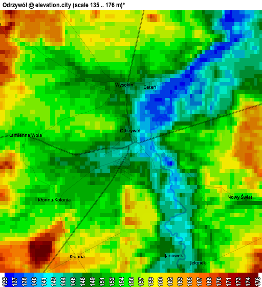
Below is the Elevation map of Odrzywół, which displays elevation range with different colors. Scale of the first map is from 135 to 176 m (443 to 577 ft) with average elevation of 153.5 meters (=504 ft) [note 1]
These maps also provides idea of topography and contour of this city, they are displayed at different zoom levels. More info about maps, scale and edge coordinates you can find below images.
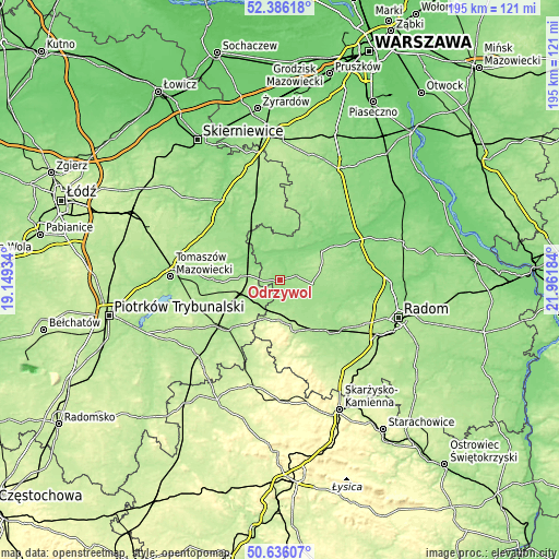
| \ | Map #1 | Topo.Map |
| Scale [m] | 135..176 m | × |
| Scale [ft] | 443..577 ft | × |
| Average | 153.5 m = 504 ft | × |
| Width | 6.08 km = 3.8 mi | 194.6 km = 120.9 mi |
| Height | 6.08 km = 3.8 mi | 194.6 km = 120.9 mi |
| ↑Max Latitude | 51.546867° | 52.38618° |
| Latitude at center | 51.51953° | 51.51953° |
| ↓Min Latitude | 51.492177° | 50.63607° |
| ← Min Longitude | 20.511645° | 19.14934° |
| Longitude center | 20.55559° | 20.55559° |
| →Max Longitude | 20.599535° | 21.96184° |
Nearby cities:
Cities around Odrzywół sort by population:
• Przysucha elevation 209 m
18.6 km,  164°
164°
• Drzewica 161 m
9.4 km,  215°
215°
• Nowe Miasto nad Pilicą 158 m
11.1 km,  7°
7°
• Mogielnica 135 m
22.6 km,  30°
30°
• Rzeczyca 164 m
20 km,  295°
295°
• Gielniów 199 m
14.2 km,  201°
201°
• Potworów 175 m
11.6 km,  95°
95°
• Wyśmierzyce 124 m
21.4 km,  56°
56°
• Rusinów 170 m
9.5 km,  166°
166°
• Klwów 158 m
5.8 km,  73°
73°
• Poświętne 163 m
13.3 km,  276°
276°
• Radzanów 158 m
21.7 km,  78°
78°
Multilingual:
 En español:
Odrzywół elevación 146 m.
 En France:
Odrzywół élévation 146 m.
 Auf Deutsch:
Odrzywół höhe über dem Meeresspiegel ist 146 m.

Sources and notes:
- [note 1] Map square and city borders are not equal. Map elevation data is calculated only from area inside that square.
- [src 1] Elevation data from geonames database provided with same terms of usage.
- [src 2] The elevation map of Odrzywół is generated using elevation data from NASA's 3 arcsec (90m) resolution SRTM data.
- [src 3] Base (background) map © OpenStreetMap contributors tiles are generated by Geofabrik and OpenTopoMap.
Copyright & License:
This Odrzywół Elevation Map is licensed under CC BY-SA. You may reuse any part from this page, if you give a proper credit by linking to this URL:
 More info on terms of use page.