Ostrówek elevation
Ostrówek (Mazovia, Powiat węgrowski), Poland elevation is 105 meters and Ostrówek elevation in feet is 344 ft above sea level [src 1]. Ostrówek is a populated place (feature code) with elevation that is 86 meters (282 ft) smaller than average city elevation in Poland.
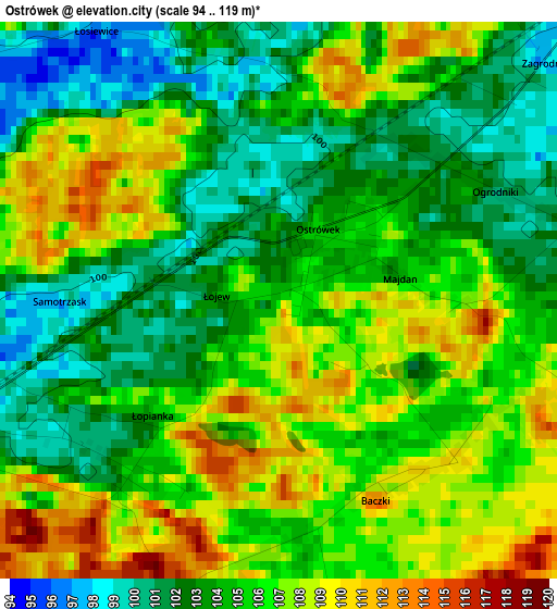
Below is the Elevation map of Ostrówek, which displays elevation range with different colors. Scale of the first map is from 94 to 119 m (308 to 390 ft) with average elevation of 104.9 meters (=344 ft) [note 1]
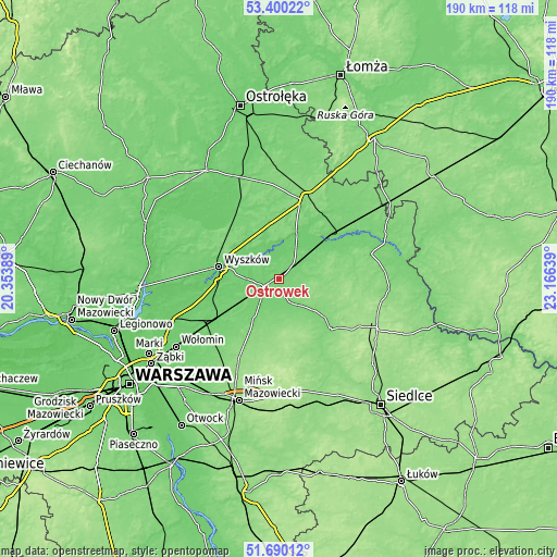
These maps also provides idea of topography and contour of this city, they are displayed at different zoom levels. More info about maps, scale and edge coordinates you can find below images.
| \ | Map #1 | Topo.Map |
| Scale [m] | 94..119 m | × |
| Scale [ft] | 308..390 ft | × |
| Average | 104.9 m = 344 ft | × |
| Width | 5.94 km = 3.7 mi | 190.1 km = 118.1 mi |
| Height | 5.94 km = 3.7 mi | 190.1 km = 118.1 mi |
| ↑Max Latitude | 52.580212° | 53.40022° |
| Latitude at center | 52.5535° | 52.5535° |
| ↓Min Latitude | 52.526772° | 51.69012° |
| ← Min Longitude | 21.716195° | 20.35389° |
| Longitude center | 21.76014° | 21.76014° |
| →Max Longitude | 21.804085° | 23.16639° |
Nearby cities:
Cities around Ostrówek sort by population:
• Wyszków elevation 92 m
20.9 km,  282°
282°
• Łochów 97 m
5.9 km,  244°
244°
• Małkinia Górna 101 m
23.8 km,  49°
49°
• Brok 106 m
17.5 km,  21°
21°
• Miedzna 149 m
24.2 km,  113°
113°
• Jadów 102 m
12 km,  226°
226°
• Sadowne 97 m
11.3 km,  30°
30°
• Brańszczyk 88 m
14.4 km,  305°
305°
• Stoczek 122 m
9.5 km,  96°
96°
• Korytnica 138 m
16.6 km,  158°
158°
• Strachówka 112 m
16.4 km,  211°
211°
• Liw 122 m
24.3 km,  144°
144°
Multilingual:
 En español:
Ostrówek elevación 105 m.
 En France:
Ostrówek élévation 105 m.
 Auf Deutsch:
Ostrówek höhe über dem Meeresspiegel ist 105 m.

Sources and notes:
- [note 1] Map square and city borders are not equal. Map elevation data is calculated only from area inside that square.
- [src 1] Elevation data from geonames database provided with same terms of usage.
- [src 2] The elevation map of Ostrówek is generated using elevation data from NASA's 3 arcsec (90m) resolution SRTM data.
- [src 3] Base (background) map © OpenStreetMap contributors tiles are generated by Geofabrik and OpenTopoMap.
Copyright & License:
This Ostrówek Elevation Map is licensed under CC BY-SA. You may reuse any part from this page, if you give a proper credit by linking to this URL:
 More info on terms of use page.