Wyszków elevation
Wyszków (Mazovia, Powiat wyszkowski), Poland elevation is 92 meters and Wyszków elevation in feet is 302 ft above sea level [src 1]. Wyszków is a populated place (feature code) with elevation that is 99 meters (325 ft) smaller than average city elevation in Poland.
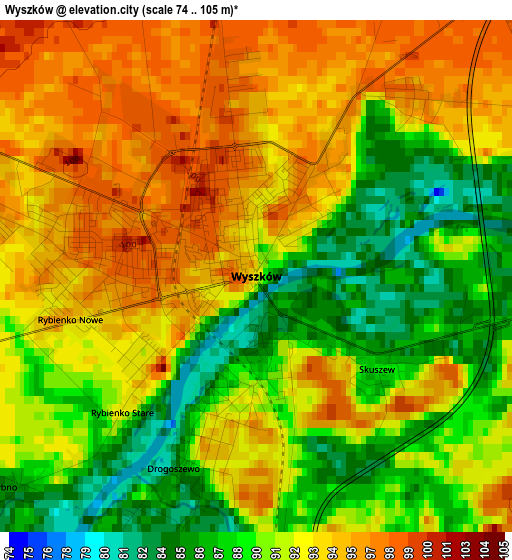
Below is the Elevation map of Wyszków, which displays elevation range with different colors. Scale of the first map is from 74 to 105 m (243 to 344 ft) with average elevation of 91.6 meters (=301 ft) [note 1]
These maps also provides idea of topography and contour of this city, they are displayed at different zoom levels. More info about maps, scale and edge coordinates you can find below images.
| \ | Map #1 | Map #2 | Topo.Map |
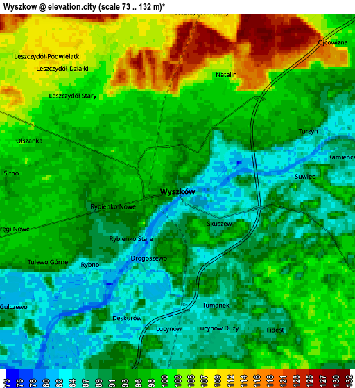
| Scale [m] | 74..105 m | 73..132 m | × |
| Scale [ft] | 243..344 ft | 240..433 ft | × |
| Average | 91.6 m = 301 ft | 96.1 m = 315 ft | × |
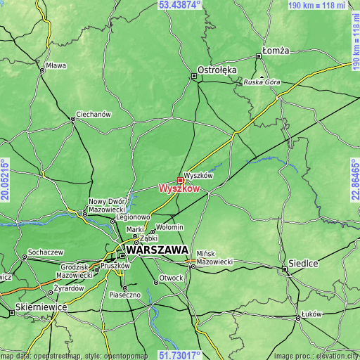
| Width | 5.94 km = 3.7 mi | 11.87 km = 7.4 mi | 190 km = 118.1 mi |
| Height | 5.94 km = 3.7 mi | 11.87 km = 7.4 mi | 190 km = 118.1 mi |
| ↑Max Latitude | 52.619468° | 52.646139° | 53.43874° |
| Latitude at center | 52.59278° | 52.59278° | 52.59278° |
| ↓Min Latitude | 52.566076° | 52.539356° | 51.73017° |
| ← Min Longitude | 21.414455° | 21.370509° | 20.05215° |
| Longitude center | 21.4584° | 21.4584° | 21.4584° |
| →Max Longitude | 21.502345° | 21.546291° | 22.86465° |
Nearby cities:
Cities around Wyszków sort by population:
• Tłuszcz elevation 101 m
18.1 km,  184°
184°
• Łochów 97 m
16.6 km,  114°
114°
• Długosiodło 102 m
20.7 km,  25°
25°
• Jasienica 98 m
20.1 km,  189°
189°
• Ostrówek 105 m
20.9 km,  102°
102°
• Rząśnik 104 m
14.7 km,  335°
335°
• Jadów 102 m
17.3 km,  137°
137°
• Brańszczyk 88 m
9.6 km,  65°
65°
• Zatory 96 m
18.6 km,  272°
272°
• Obryte 109 m
19.7 km,  314°
314°
• Dąbrówka 89 m
16.3 km,  221°
221°
• Strachówka 112 m
22 km,  147°
147°
Multilingual:
 En español:
Wyszków elevación 92 m.
 En France:
Wyszków élévation 92 m.


Sources and notes:
- [note 1] Map square and city borders are not equal. Map elevation data is calculated only from area inside that square.
- [src 1] Elevation data from geonames database provided with same terms of usage.
- [src 2] The elevation map of Wyszków is generated using elevation data from NASA's 3 arcsec (90m) resolution SRTM data.
- [src 3] Base (background) map © OpenStreetMap contributors tiles are generated by Geofabrik and OpenTopoMap.
Copyright & License:
This Wyszków Elevation Map is licensed under CC BY-SA. You may reuse any part from this page, if you give a proper credit by linking to this URL:
 More info on terms of use page.