Padew Narodowa elevation
Padew Narodowa (Subcarpathian, Powiat mielecki), Poland elevation is 153 meters and Padew Narodowa elevation in feet is 502 ft above sea level [src 1]. Padew Narodowa is a populated place (feature code) with elevation that is 38 meters (125 ft) smaller than average city elevation in Poland.
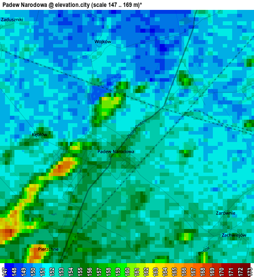
Below is the Elevation map of Padew Narodowa, which displays elevation range with different colors. Scale of the first map is from 147 to 169 m (482 to 554 ft) with average elevation of 151.9 meters (=498 ft) [note 1]
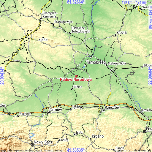
These maps also provides idea of topography and contour of this city, they are displayed at different zoom levels. More info about maps, scale and edge coordinates you can find below images.
| \ | Map #1 | Topo.Map |
| Scale [m] | 147..169 m | × |
| Scale [ft] | 482..554 ft | × |
| Average | 151.9 m = 498 ft | × |
| Width | 6.22 km = 3.9 mi | 199.2 km = 123.8 mi |
| Height | 6.22 km = 3.9 mi | 199.2 km = 123.8 mi |
| ↑Max Latitude | 50.46745° | 51.32664° |
| Latitude at center | 50.43947° | 50.43947° |
| ↓Min Latitude | 50.411473° | 49.53535° |
| ← Min Longitude | 21.456645° | 20.09434° |
| Longitude center | 21.50059° | 21.50059° |
| →Max Longitude | 21.544535° | 22.90684° |
Nearby cities:
Cities around Padew Narodowa sort by population:
• Mielec elevation 178 m
17.8 km,  197°
197°
• Tarnobrzeg 162 m
19.5 km,  40°
40°
• Nowa Dęba 162 m
17.8 km,  93°
93°
• Połaniec 164 m
15.6 km,  267°
267°
• Majdan Królewski 215 m
18.6 km,  111°
111°
• Koprzywnica 165 m
18.1 km,  18°
18°
• Osiek 180 m
9.9 km,  335°
335°
• Czermin 161 m
16.3 km,  226°
226°
• Borowa 157 m
12.2 km,  240°
240°
• Baranów Sandomierski 150 m
7.3 km, 23°
• Trzciana 163 m
18.7 km,  218°
218°
• Łoniów 172 m
14 km,  7°
7°
Multilingual:
 En español:
Padew Narodowa elevación 153 m.
 En France:
Padew Narodowa élévation 153 m.
 Auf Deutsch:
Padew Narodowa höhe über dem Meeresspiegel ist 153 m.

Sources and notes:
- [note 1] Map square and city borders are not equal. Map elevation data is calculated only from area inside that square.
- [src 1] Elevation data from geonames database provided with same terms of usage.
- [src 2] The elevation map of Padew Narodowa is generated using elevation data from NASA's 3 arcsec (90m) resolution SRTM data.
- [src 3] Base (background) map © OpenStreetMap contributors tiles are generated by Geofabrik and OpenTopoMap.
Copyright & License:
This Padew Narodowa Elevation Map is licensed under CC BY-SA. You may reuse any part from this page, if you give a proper credit by linking to this URL:
 More info on terms of use page.