Paprotnia elevation
Paprotnia (Mazovia, Powiat sochaczewski), Poland elevation is 89 meters and Paprotnia elevation in feet is 292 ft above sea level [src 1]. Paprotnia is a populated place (feature code) with elevation that is 102 meters (335 ft) smaller than average city elevation in Poland.
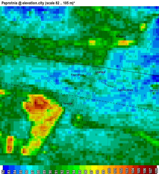
Below is the Elevation map of Paprotnia, which displays elevation range with different colors. Scale of the first map is from 82 to 105 m (269 to 344 ft) with average elevation of 88.6 meters (=291 ft) [note 1]
These maps also provides idea of topography and contour of this city, they are displayed at different zoom levels. More info about maps, scale and edge coordinates you can find below images.
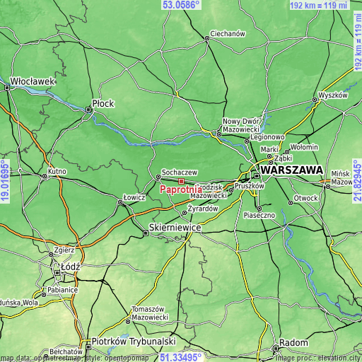
| \ | Map #1 | Topo.Map |
| Scale [m] | 82..105 m | × |
| Scale [ft] | 269..344 ft | × |
| Average | 88.6 m = 291 ft | × |
| Width | 5.99 km = 3.7 mi | 191.7 km = 119.1 mi |
| Height | 5.99 km = 3.7 mi | 191.6 km = 119.1 mi |
| ↑Max Latitude | 52.232053° | 53.0586° |
| Latitude at center | 52.20513° | 52.20513° |
| ↓Min Latitude | 52.178191° | 51.33495° |
| ← Min Longitude | 20.379255° | 19.01695° |
| Longitude center | 20.4232° | 20.4232° |
| →Max Longitude | 20.467145° | 21.82945° |
Nearby cities:
Cities around Paprotnia sort by population:
• Żyrardów elevation 118 m
17.5 km,  174°
174°
• Sochaczew 87 m
12.9 km,  282°
282°
• Grodzisk Mazowiecki 103 m
18.2 km,  128°
128°
• Błonie 88 m
13.2 km,  93°
93°
• Leszno 91 m
12.9 km,  62°
62°
• Teresin 87 m
0.8 km,  212°
212°
• Wiskitki 100 m
13.2 km,  190°
190°
• Młodzieszyn 74 m
18.5 km,  304°
304°
• Bieniewice 91 m
9.9 km,  104°
104°
• Guzów 99 m
11.5 km, 210°
• Kampinos 85 m
7.5 km,  21°
21°
• Brochów 69 m
16.8 km,  319°
319°
Multilingual:
 En español:
Paprotnia elevación 89 m.
 En France:
Paprotnia élévation 89 m.
 Auf Deutsch:
Paprotnia höhe über dem Meeresspiegel ist 89 m.

Sources and notes:
- [note 1] Map square and city borders are not equal. Map elevation data is calculated only from area inside that square.
- [src 1] Elevation data from geonames database provided with same terms of usage.
- [src 2] The elevation map of Paprotnia is generated using elevation data from NASA's 3 arcsec (90m) resolution SRTM data.
- [src 3] Base (background) map © OpenStreetMap contributors tiles are generated by Geofabrik and OpenTopoMap.
Copyright & License:
This Paprotnia Elevation Map is licensed under CC BY-SA. You may reuse any part from this page, if you give a proper credit by linking to this URL:
 More info on terms of use page.