Raszyn elevation
Raszyn (Mazovia, Powiat pruszkowski), Poland elevation is 102 meters and Raszyn elevation in feet is 335 ft above sea level [src 1]. Raszyn is a populated place (feature code) with elevation that is 89 meters (292 ft) smaller than average city elevation in Poland.
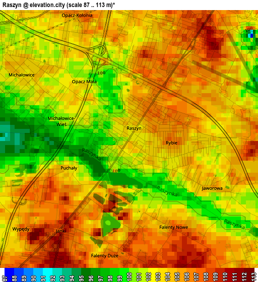
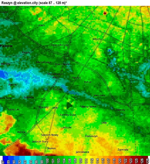
Below is the Elevation map of Raszyn, which displays elevation range with different colors. Scale of the first map is from 87 to 113 m (285 to 371 ft) with average elevation of 103.2 meters (=339 ft) [note 1]
These maps also provides idea of topography and contour of this city, they are displayed at different zoom levels. More info about maps, scale and edge coordinates you can find below images.
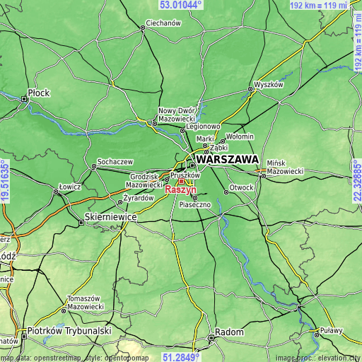
| \ | Map #1 | Map #2 | Topo.Map |
| Scale [m] | 87..113 m | 87..128 m | × |
| Scale [ft] | 285..371 ft | 285..420 ft | × |
| Average | 103.2 m = 339 ft | 104.8 m = 344 ft | × |
| Width | 6 km = 3.7 mi | 11.99 km = 7.5 mi | 191.9 km = 119.2 mi |
| Height | 6 km = 3.7 mi | 11.99 km = 7.5 mi | 191.8 km = 119.2 mi |
| ↑Max Latitude | 52.182983° | 52.209919° | 53.01044° |
| Latitude at center | 52.15603° | 52.15603° | 52.15603° |
| ↓Min Latitude | 52.129061° | 52.102075° | 51.2849° |
| ← Min Longitude | 20.878655° | 20.834709° | 19.51635° |
| Longitude center | 20.9226° | 20.9226° | 20.9226° |
| →Max Longitude | 20.966545° | 21.010491° | 22.32885° |
Nearby cities:
Cities around Raszyn sort by population:
• Mokotów elevation 83 m
8.7 km,  61°
61°
• Ochota 118 m
8.4 km,  30°
30°
• Pruszków 92 m
7.7 km,  282°
282°
• Ursus 105 m
5.1 km,  328°
328°
• Włochy 109 m
3.1 km, 31°
• Piastów 98 m
6.5 km,  299°
299°
• Lesznowola 116 m
7.3 km,  173°
173°
• Komorów 108 m
7.4 km,  260°
260°
• Rybie 103 m
1 km,  113°
113°
• Michałowice 102 m
3.5 km,  305°
305°
• Granica 100 m
8.5 km,  252°
252°
• Nowe Grocholice 99 m
0.9 km,  294°
294°
Multilingual:
 En español:
Raszyn elevación 102 m.
 En France:
Raszyn élévation 102 m.


Sources and notes:
- [note 1] Map square and city borders are not equal. Map elevation data is calculated only from area inside that square.
- [src 1] Elevation data from geonames database provided with same terms of usage.
- [src 2] The elevation map of Raszyn is generated using elevation data from NASA's 3 arcsec (90m) resolution SRTM data.
- [src 3] Base (background) map © OpenStreetMap contributors tiles are generated by Geofabrik and OpenTopoMap.
Copyright & License:
This Raszyn Elevation Map is licensed under CC BY-SA. You may reuse any part from this page, if you give a proper credit by linking to this URL:
 More info on terms of use page.