Ryki elevation
Ryki (Lublin, Powiat rycki), Poland elevation is 149 meters and Ryki elevation in feet is 489 ft above sea level [src 1]. Ryki is a seat of a second-order administrative division (feature code) with elevation that is 42 meters (138 ft) smaller than average city elevation in Poland.
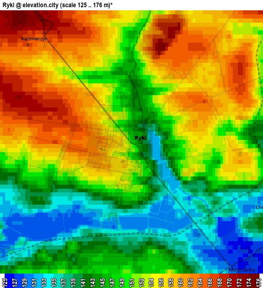
Below is the Elevation map of Ryki, which displays elevation range with different colors. Scale of the first map is from 125 to 176 m (410 to 577 ft) with average elevation of 150.4 meters (=493 ft) [note 1]
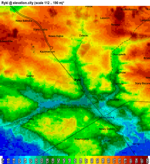
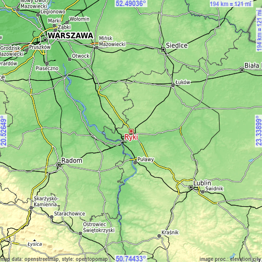
These maps also provides idea of topography and contour of this city, they are displayed at different zoom levels. More info about maps, scale and edge coordinates you can find below images.
| \ | Map #1 | Map #2 | Topo.Map |
| Scale [m] | 125..176 m | 112..190 m | × |
| Scale [ft] | 410..577 ft | 367..623 ft | × |
| Average | 150.4 m = 493 ft | 153.1 m = 502 ft | × |
| Width | 6.07 km = 3.8 mi | 12.13 km = 7.5 mi | 194.1 km = 120.6 mi |
| Height | 6.07 km = 3.8 mi | 12.13 km = 7.5 mi | 194.1 km = 120.6 mi |
| ↑Max Latitude | 51.653013° | 51.680269° | 52.49036° |
| Latitude at center | 51.62574° | 51.62574° | 51.62574° |
| ↓Min Latitude | 51.598451° | 51.571145° | 50.74433° |
| ← Min Longitude | 21.888795° | 21.844849° | 20.52649° |
| Longitude center | 21.93274° | 21.93274° | 21.93274° |
| →Max Longitude | 21.976685° | 22.020631° | 23.33899° |
Nearby cities:
Cities around Ryki sort by population:
• Dęblin elevation 115 m
9.4 km,  218°
218°
• Żelechów 171 m
20.7 km,  353°
353°
• Sobolew 159 m
22.3 km,  303°
303°
• Stężyca 113 m
12.2 km,  246°
246°
• Ułęż 143 m
12.6 km,  107°
107°
• Baranów 133 m
16 km,  118°
118°
• Żyrzyn 153 m
17.9 km,  142°
142°
• Przytoczno 136 m
23.4 km,  91°
91°
• Podebłocie 148 m
13.1 km,  277°
277°
• Kłoczew 157 m
10.9 km,  11°
11°
• Trojanów 143 m
11.2 km,  311°
311°
• Nowodwór 157 m
11.8 km,  82°
82°
Multilingual:
 En español:
Ryki elevación 149 m.
 En France:
Ryki élévation 149 m.


Sources and notes:
- [note 1] Map square and city borders are not equal. Map elevation data is calculated only from area inside that square.
- [src 1] Elevation data from geonames database provided with same terms of usage.
- [src 2] The elevation map of Ryki is generated using elevation data from NASA's 3 arcsec (90m) resolution SRTM data.
- [src 3] Base (background) map © OpenStreetMap contributors tiles are generated by Geofabrik and OpenTopoMap.
Copyright & License:
This Ryki Elevation Map is licensed under CC BY-SA. You may reuse any part from this page, if you give a proper credit by linking to this URL:
 More info on terms of use page.