Zagórz elevation
Zagórz (Subcarpathian, Powiat sanocki), Poland elevation is 303 meters and Zagórz elevation in feet is 994 ft above sea level [src 1]. Zagórz is a seat of a third-order administrative division (feature code) with elevation that is 112 meters (367 ft) bigger than average city elevation in Poland.
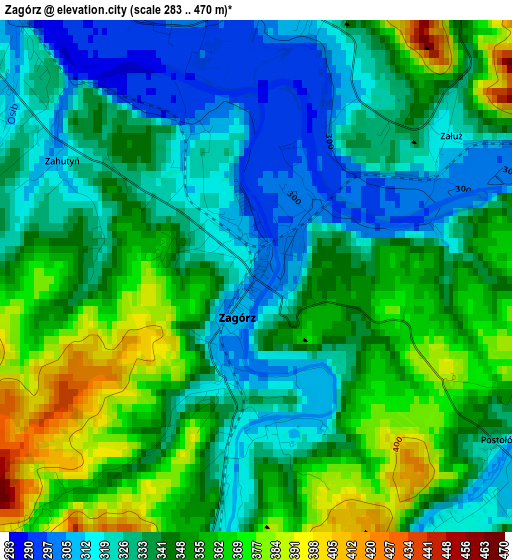
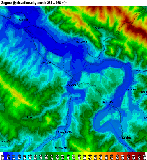
Below is the Elevation map of Zagórz, which displays elevation range with different colors. Scale of the first map is from 283 to 470 m (928 to 1542 ft) with average elevation of 342 meters (=1122 ft) [note 1]
These maps also provides idea of topography and contour of this city, they are displayed at different zoom levels. More info about maps, scale and edge coordinates you can find below images.
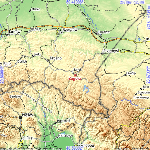
| \ | Map #1 | Map #2 | Topo.Map |
| Scale [m] | 283..470 m | 281..668 m | × |
| Scale [ft] | 928..1542 ft | 922..2192 ft | × |
| Average | 342 m = 1122 ft | 379.8 m = 1246 ft | × |
| Width | 6.34 km = 3.9 mi | 12.69 km = 7.9 mi | 203 km = 126.1 mi |
| Height | 6.34 km = 3.9 mi | 12.69 km = 7.9 mi | 203 km = 126.1 mi |
| ↑Max Latitude | 49.543093° | 49.5716° | 50.41908° |
| Latitude at center | 49.51457° | 49.51457° | 49.51457° |
| ↓Min Latitude | 49.48603° | 49.457473° | 48.59302° |
| ← Min Longitude | 22.223115° | 22.179169° | 20.86081° |
| Longitude center | 22.26706° | 22.26706° | 22.26706° |
| →Max Longitude | 22.311005° | 22.354951° | 23.67331° |
Nearby cities:
Cities around Zagórz sort by population:
• Sanok elevation 289 m
6.4 km,  315°
315°
• Lesko 362 m
6.7 km,  137°
137°
• Długie 292 m
17.6 km,  293°
293°
• Niebieszczany 360 m
8.1 km,  261°
261°
• Bukowsko 392 m
15.2 km, 255°
• Czaszyn 367 m
8.2 km,  206°
206°
• Uherce Mineralne 358 m
11 km,  120°
120°
• Poraż 384 m
4.4 km,  223°
223°
• Nowosielce-Gniewosz 305 m
15.5 km, 292°
• Strachocina 315 m
16.6 km,  308°
308°
• Olszanica 374 m
13.4 km,  107°
107°
• Tyrawa Wołoska 326 m
10.2 km,  46°
46°
Multilingual:
 En español:
Zagórz elevación 303 m.
 En France:
Zagórz élévation 303 m.


Sources and notes:
- [note 1] Map square and city borders are not equal. Map elevation data is calculated only from area inside that square.
- [src 1] Elevation data from geonames database provided with same terms of usage.
- [src 2] The elevation map of Zagórz is generated using elevation data from NASA's 3 arcsec (90m) resolution SRTM data.
- [src 3] Base (background) map © OpenStreetMap contributors tiles are generated by Geofabrik and OpenTopoMap.
Copyright & License:
This Zagórz Elevation Map is licensed under CC BY-SA. You may reuse any part from this page, if you give a proper credit by linking to this URL:
 More info on terms of use page.