Zambrów elevation
Zambrów (Podlasie, Powiat zambrowski), Poland elevation is 125 meters and Zambrów elevation in feet is 410 ft above sea level [src 1]. Zambrów is a populated place (feature code) with elevation that is 66 meters (217 ft) smaller than average city elevation in Poland.
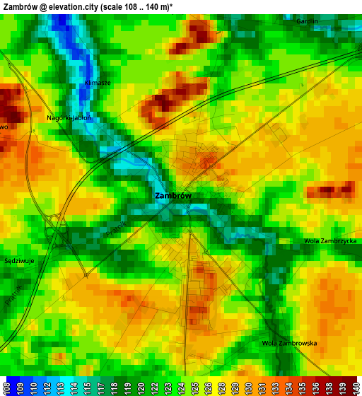
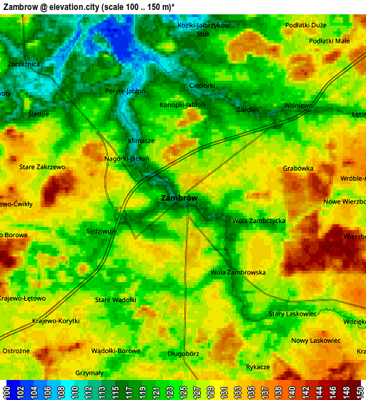
Below is the Elevation map of Zambrów, which displays elevation range with different colors. Scale of the first map is from 108 to 140 m (354 to 459 ft) with average elevation of 124.8 meters (=409 ft) [note 1]
These maps also provides idea of topography and contour of this city, they are displayed at different zoom levels. More info about maps, scale and edge coordinates you can find below images.
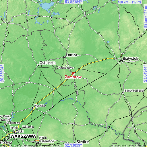
| \ | Map #1 | Map #2 | Topo.Map |
| Scale [m] | 108..140 m | 100..150 m | × |
| Scale [ft] | 354..459 ft | 328..492 ft | × |
| Average | 124.8 m = 409 ft | 126 m = 413 ft | × |
| Width | 5.88 km = 3.7 mi | 11.77 km = 7.3 mi | 188.3 km = 117 mi |
| Height | 5.88 km = 3.7 mi | 11.77 km = 7.3 mi | 188.3 km = 117 mi |
| ↑Max Latitude | 53.011948° | 53.038379° | 53.82381° |
| Latitude at center | 52.9855° | 52.9855° | 52.9855° |
| ↓Min Latitude | 52.959036° | 52.932556° | 52.13059° |
| ← Min Longitude | 22.199245° | 22.155299° | 20.83694° |
| Longitude center | 22.24319° | 22.24319° | 22.24319° |
| →Max Longitude | 22.287135° | 22.331081° | 23.64944° |
Nearby cities:
Cities around Zambrów sort by population:
• Łomża elevation 103 m
24.7 km,  330°
330°
• Ostrów Mazowiecka 122 m
31 km,  228°
228°
• Wysokie Mazowieckie 143 m
19.9 km,  112°
112°
• Czyżew 121 m
21.4 km,  167°
167°
• Szepietowo 148 m
23.9 km,  122°
122°
• Piątnica 104 m
25.4 km,  337°
337°
• Śniadowo 126 m
17.9 km,  289°
289°
• Sokoły 151 m
30.6 km,  88°
88°
• Wizna 119 m
25.1 km,  21°
21°
• Rutki-Kossaki 142 m
17.5 km,  48°
48°
• Szumowo 133 m
13 km,  235°
235°
• Rutki 117 m
18 km,  44°
44°
Multilingual:
 En español:
Zambrów elevación 125 m.
 En France:
Zambrów élévation 125 m.


Sources and notes:
- [note 1] Map square and city borders are not equal. Map elevation data is calculated only from area inside that square.
- [src 1] Elevation data from geonames database provided with same terms of usage.
- [src 2] The elevation map of Zambrów is generated using elevation data from NASA's 3 arcsec (90m) resolution SRTM data.
- [src 3] Base (background) map © OpenStreetMap contributors tiles are generated by Geofabrik and OpenTopoMap.
Copyright & License:
This Zambrów Elevation Map is licensed under CC BY-SA. You may reuse any part from this page, if you give a proper credit by linking to this URL:
 More info on terms of use page.