Zgorzelisko elevation
Zgorzelisko (Lower Silesia, Wrocław), Poland elevation is 120 meters and Zgorzelisko elevation in feet is 394 ft above sea level [src 1]. Zgorzelisko is a section of populated place (feature code) with elevation that is 71 meters (233 ft) smaller than average city elevation in Poland.
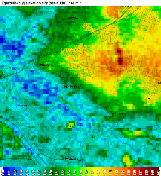
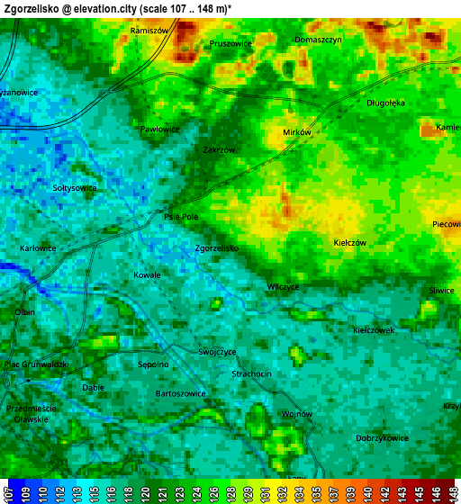
Below is the Elevation map of Zgorzelisko, which displays elevation range with different colors. Scale of the first map is from 110 to 141 m (361 to 463 ft) with average elevation of 120.6 meters (=396 ft) [note 1]
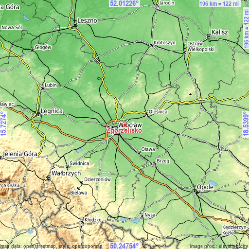
These maps also provides idea of topography and contour of this city, they are displayed at different zoom levels. More info about maps, scale and edge coordinates you can find below images.
| \ | Map #1 | Map #2 | Topo.Map |
| Scale [m] | 110..141 m | 107..148 m | × |
| Scale [ft] | 361..463 ft | 351..486 ft | × |
| Average | 120.6 m = 396 ft | 121 m = 397 ft | × |
| Width | 6.13 km = 3.8 mi | 12.26 km = 7.6 mi | 196.2 km = 121.9 mi |
| Height | 6.13 km = 3.8 mi | 12.26 km = 7.6 mi | 196.2 km = 121.9 mi |
| ↑Max Latitude | 51.165895° | 51.193443° | 52.01226° |
| Latitude at center | 51.13833° | 51.13833° | 51.13833° |
| ↓Min Latitude | 51.110749° | 51.083151° | 50.24754° |
| ← Min Longitude | 17.089705° | 17.045759° | 15.7274° |
| Longitude center | 17.13365° | 17.13365° | 17.13365° |
| →Max Longitude | 17.177595° | 17.221541° | 18.5399° |
Nearby cities:
Cities around Zgorzelisko sort by population:
• Zakrzów elevation 120 m
3.1 km,  4°
4°
• Sępolno 119 m
3.9 km,  214°
214°
• Psie Pole Południe-Kiełczów 130 m
1.1 km,  337°
337°
• Strachocin-Wojnów 118 m
3.9 km,  162°
162°
• Rejon alei Kromera 113 m
4.4 km,  263°
263°
• Kiełczów 131 m
3.1 km,  86°
86°
• Pawłowice-Kłokoczyce 118 m
3.9 km,  320°
320°
• Kowale-Popiele 114 m
2.4 km,  249°
249°
• Wilczyce 123 m
1.8 km,  123°
123°
• Zalesie i Stadion 117 m
3.6 km,  234°
234°
• Swojczyce 117 m
2.6 km,  192°
192°
• Mirków 128 m
3.6 km,  45°
45°
Multilingual:
 En español:
Zgorzelisko elevación 120 m.
 En France:
Zgorzelisko élévation 120 m.
 Auf Deutsch:
Zgorzelisko höhe über dem Meeresspiegel ist 120 m.

Sources and notes:
- [note 1] Map square and city borders are not equal. Map elevation data is calculated only from area inside that square.
- [src 1] Elevation data from geonames database provided with same terms of usage.
- [src 2] The elevation map of Zgorzelisko is generated using elevation data from NASA's 3 arcsec (90m) resolution SRTM data.
- [src 3] Base (background) map © OpenStreetMap contributors tiles are generated by Geofabrik and OpenTopoMap.
Copyright & License:
This Zgorzelisko Elevation Map is licensed under CC BY-SA. You may reuse any part from this page, if you give a proper credit by linking to this URL:
 More info on terms of use page.