Lubicz Dolny elevation
Lubicz Dolny (Kujawsko-Pomorskie, Powiat toruński), Poland elevation is 63 meters and Lubicz Dolny elevation in feet is 207 ft above sea level [src 1]. Lubicz Dolny is a populated place (feature code) with elevation that is 128 meters (420 ft) smaller than average city elevation in Poland.
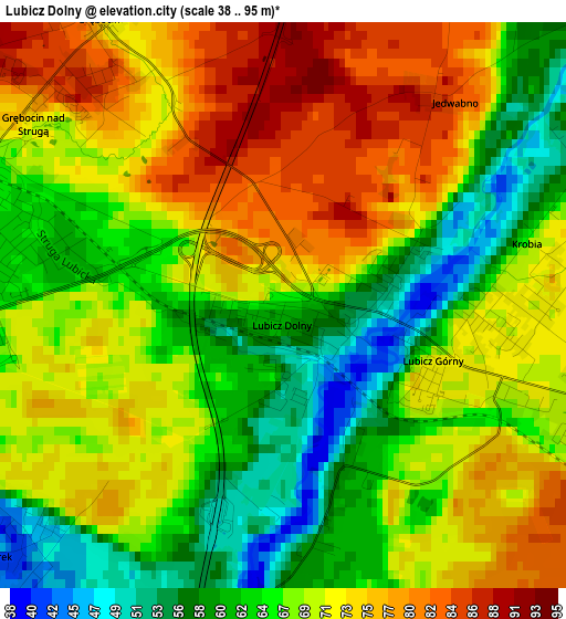
Below is the Elevation map of Lubicz Dolny, which displays elevation range with different colors. Scale of the first map is from 38 to 95 m (125 to 312 ft) with average elevation of 68.7 meters (=225 ft) [note 1]
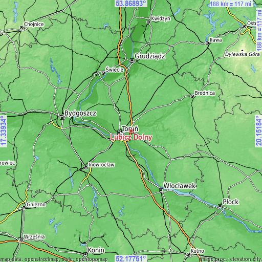
These maps also provides idea of topography and contour of this city, they are displayed at different zoom levels. More info about maps, scale and edge coordinates you can find below images.
| \ | Map #1 | Topo.Map |
| Scale [m] | 38..95 m | × |
| Scale [ft] | 125..312 ft | × |
| Average | 68.7 m = 225 ft | × |
| Width | 5.88 km = 3.7 mi | 188.1 km = 116.9 mi |
| Height | 5.88 km = 3.7 mi | 188.1 km = 116.9 mi |
| ↑Max Latitude | 53.05793° | 53.86893° |
| Latitude at center | 53.03151° | 53.03151° |
| ↓Min Latitude | 53.005074° | 52.17751° |
| ← Min Longitude | 18.701645° | 17.33934° |
| Longitude center | 18.74559° | 18.74559° |
| →Max Longitude | 18.789535° | 20.15184° |
Nearby cities:
Cities around Lubicz Dolny sort by population:
• Toruń elevation 51 m
10.1 km,  258°
258°
• Chełmża 88 m
19.5 km,  331°
331°
• Aleksandrów Kujawski 72 m
17.6 km,  191°
191°
• Ciechocinek 46 m
17.3 km,  168°
168°
• Kowalewo Pomorskie 92 m
17.1 km,  36°
36°
• Lubicz Górny 71 m
1.8 km,  106°
106°
• Czernikowo 95 m
16 km,  126°
126°
• Obrowo 90 m
11.1 km, 126°
• Łysomice 80 m
10.4 km,  305°
305°
• Osiek 56 m
12.4 km,  160°
160°
• Ciechocin 84 m
12.4 km,  77°
77°
• Wielka Nieszawka 37 m
16.3 km, 256°
Multilingual:
 En español:
Lubicz Dolny elevación 63 m.
 En France:
Lubicz Dolny élévation 63 m.
 Auf Deutsch:
Lubicz Dolny höhe über dem Meeresspiegel ist 63 m.

Sources and notes:
- [note 1] Map square and city borders are not equal. Map elevation data is calculated only from area inside that square.
- [src 1] Elevation data from geonames database provided with same terms of usage.
- [src 2] The elevation map of Lubicz Dolny is generated using elevation data from NASA's 3 arcsec (90m) resolution SRTM data.
- [src 3] Base (background) map © OpenStreetMap contributors tiles are generated by Geofabrik and OpenTopoMap.
Copyright & License:
This Lubicz Dolny Elevation Map is licensed under CC BY-SA. You may reuse any part from this page, if you give a proper credit by linking to this URL:
 More info on terms of use page.