Ostrówek elevation
Ostrówek (Mazovia, Powiat wołomiński), Poland elevation is 98 meters and Ostrówek elevation in feet is 322 ft above sea level [src 1]. Ostrówek is a populated place (feature code) with elevation that is 93 meters (305 ft) smaller than average city elevation in Poland.
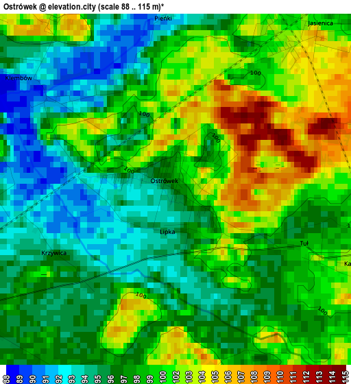
Below is the Elevation map of Ostrówek, which displays elevation range with different colors. Scale of the first map is from 88 to 115 m (289 to 377 ft) with average elevation of 98.8 meters (=324 ft) [note 1]
These maps also provides idea of topography and contour of this city, they are displayed at different zoom levels. More info about maps, scale and edge coordinates you can find below images.
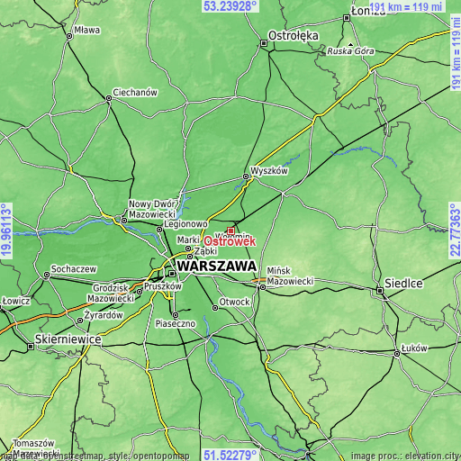
| \ | Map #1 | Topo.Map |
| Scale [m] | 88..115 m | × |
| Scale [ft] | 289..377 ft | × |
| Average | 98.8 m = 324 ft | × |
| Width | 5.96 km = 3.7 mi | 190.9 km = 118.6 mi |
| Height | 5.96 km = 3.7 mi | 190.8 km = 118.6 mi |
| ↑Max Latitude | 52.416191° | 53.23928° |
| Latitude at center | 52.38938° | 52.38938° |
| ↓Min Latitude | 52.362552° | 51.52279° |
| ← Min Longitude | 21.323435° | 19.96113° |
| Longitude center | 21.36738° | 21.36738° |
| →Max Longitude | 21.411325° | 22.77363° |
Nearby cities:
Cities around Ostrówek sort by population:
• Wołomin elevation 96 m
10.1 km,  237°
237°
• Kobyłka 93 m
12.9 km, 244°
• Radzymin 90 m
12.8 km,  283°
283°
• Tłuszcz 101 m
6.5 km,  45°
45°
• Duczki 97 m
6 km, 240°
• Stanisławów 147 m
16.6 km,  132°
132°
• Jasienica 98 m
4.1 km, 47°
• Słupno 88 m
14.4 km,  267°
267°
• Nowe Lipiny 94 m
7.4 km, 241°
• Klembów 93 m
3.1 km,  308°
308°
• Dąbrówka 89 m
11.5 km,  335°
335°
• Poświętne 112 m
7.6 km,  151°
151°
Multilingual:
 En español:
Ostrówek elevación 98 m.
 En France:
Ostrówek élévation 98 m.


Sources and notes:
- [note 1] Map square and city borders are not equal. Map elevation data is calculated only from area inside that square.
- [src 1] Elevation data from geonames database provided with same terms of usage.
- [src 2] The elevation map of Ostrówek is generated using elevation data from NASA's 3 arcsec (90m) resolution SRTM data.
- [src 3] Base (background) map © OpenStreetMap contributors tiles are generated by Geofabrik and OpenTopoMap.
Copyright & License:
This Ostrówek Elevation Map is licensed under CC BY-SA. You may reuse any part from this page, if you give a proper credit by linking to this URL:
 More info on terms of use page.