Ciasna elevation
Ciasna (Silesia, Powiat lubliniecki), Poland elevation is 243 meters and Ciasna elevation in feet is 797 ft above sea level [src 1]. Ciasna is a populated place (feature code) with elevation that is 52 meters (171 ft) bigger than average city elevation in Poland.
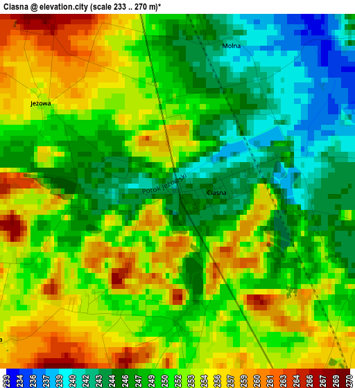
Below is the Elevation map of Ciasna, which displays elevation range with different colors. Scale of the first map is from 233 to 270 m (764 to 886 ft) with average elevation of 250.3 meters (=821 ft) [note 1]
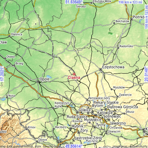
These maps also provides idea of topography and contour of this city, they are displayed at different zoom levels. More info about maps, scale and edge coordinates you can find below images.
| \ | Map #1 | Topo.Map |
| Scale [m] | 233..270 m | × |
| Scale [ft] | 764..886 ft | × |
| Average | 250.3 m = 821 ft | × |
| Width | 6.18 km = 3.8 mi | 197.8 km = 122.9 mi |
| Height | 6.18 km = 3.8 mi | 197.8 km = 122.9 mi |
| ↑Max Latitude | 50.782064° | 51.63549° |
| Latitude at center | 50.75427° | 50.75427° |
| ↓Min Latitude | 50.72646° | 49.85614° |
| ← Min Longitude | 18.564405° | 17.2021° |
| Longitude center | 18.60835° | 18.60835° |
| →Max Longitude | 18.652295° | 20.0146° |
Nearby cities:
Cities around Ciasna sort by population:
• Lubliniec elevation 258 m
10.9 km,  150°
150°
• Olesno 239 m
19 km,  316°
316°
• Zawadzkie 212 m
18.7 km,  207°
207°
• Dobrodzień 234 m
11.8 km,  256°
256°
• Kolonowskie 199 m
19.3 km,  234°
234°
• Herby 284 m
19.6 km,  90°
90°
• Przystajń 255 m
15.7 km,  21°
21°
• Kochanowice 275 m
11.3 km,  118°
118°
• Panki 236 m
17.5 km,  35°
35°
• Sieraków Śląski 247 m
5.9 km,  336°
336°
• Zębowice 219 m
18.6 km,  272°
272°
• Pawonków 261 m
6.9 km,  196°
196°
Multilingual:
 En español:
Ciasna elevación 243 m.
 En France:
Ciasna élévation 243 m.


Sources and notes:
- [note 1] Map square and city borders are not equal. Map elevation data is calculated only from area inside that square.
- [src 1] Elevation data from geonames database provided with same terms of usage.
- [src 2] The elevation map of Ciasna is generated using elevation data from NASA's 3 arcsec (90m) resolution SRTM data.
- [src 3] Base (background) map © OpenStreetMap contributors tiles are generated by Geofabrik and OpenTopoMap.
Copyright & License:
This Ciasna Elevation Map is licensed under CC BY-SA. You may reuse any part from this page, if you give a proper credit by linking to this URL:
 More info on terms of use page.