Długomiłowice elevation
Długomiłowice (Opole Voivodeship, Powiat kędzierzyńsko-kozielski), Poland elevation is 185 meters and Długomiłowice elevation in feet is 607 ft above sea level [src 1]. Długomiłowice is a populated place (feature code) with elevation that is 6 meters (20 ft) smaller than average city elevation in Poland.
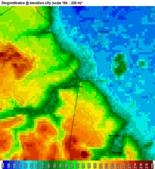
Below is the Elevation map of Długomiłowice, which displays elevation range with different colors. Scale of the first map is from 164 to 220 m (538 to 722 ft) with average elevation of 186.7 meters (=613 ft) [note 1]
These maps also provides idea of topography and contour of this city, they are displayed at different zoom levels. More info about maps, scale and edge coordinates you can find below images.
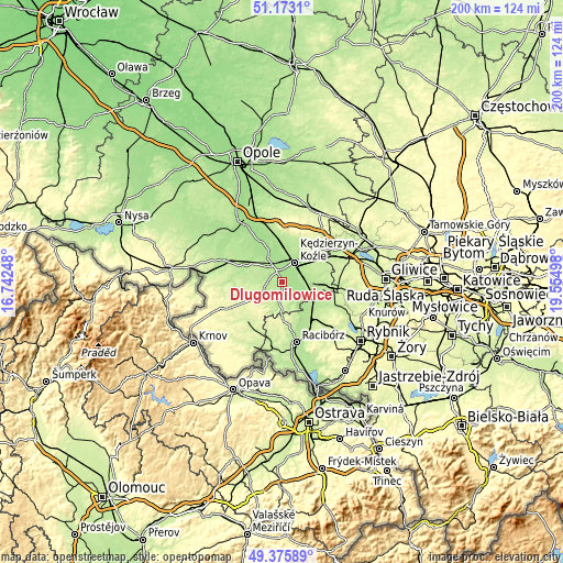
| \ | Map #1 | Topo.Map |
| Scale [m] | 164..220 m | × |
| Scale [ft] | 538..722 ft | × |
| Average | 186.7 m = 613 ft | × |
| Width | 6.24 km = 3.9 mi | 199.8 km = 124.1 mi |
| Height | 6.24 km = 3.9 mi | 199.8 km = 124.1 mi |
| ↑Max Latitude | 50.311053° | 51.1731° |
| Latitude at center | 50.28298° | 50.28298° |
| ↓Min Latitude | 50.254891° | 49.37589° |
| ← Min Longitude | 18.104785° | 16.74248° |
| Longitude center | 18.14873° | 18.14873° |
| →Max Longitude | 18.192675° | 19.55498° |
Nearby cities:
Cities around Długomiłowice sort by population:
• Kędzierzyn-Koźle elevation 182 m
9.2 km,  36°
36°
• Koźle 171 m
5.9 km,  356°
356°
• Dziergowice 185 m
10.8 km,  114°
114°
• Reńska Wieś 181 m
4 km,  336°
336°
• Cisek 173 m
3.6 km,  91°
91°
• Polska Cerekiew 199 m
6.3 km,  194°
194°
• Bierawa 177 m
6.6 km, 91°
• Pawłowiczki 224 m
8.2 km,  240°
240°
• Januszkowice 173 m
12.1 km, 356°
• Większyce 189 m
6.8 km,  331°
331°
• Raszowa 188 m
12.9 km,  8°
8°
• Twardawa 193 m
13.1 km,  300°
300°
Multilingual:
 En español:
Długomiłowice elevación 185 m.
 En France:
Długomiłowice élévation 185 m.
 Auf Deutsch:
Długomiłowice höhe über dem Meeresspiegel ist 185 m.

Sources and notes:
- [note 1] Map square and city borders are not equal. Map elevation data is calculated only from area inside that square.
- [src 1] Elevation data from geonames database provided with same terms of usage.
- [src 2] The elevation map of Długomiłowice is generated using elevation data from NASA's 3 arcsec (90m) resolution SRTM data.
- [src 3] Base (background) map © OpenStreetMap contributors tiles are generated by Geofabrik and OpenTopoMap.
Copyright & License:
This Długomiłowice Elevation Map is licensed under CC BY-SA. You may reuse any part from this page, if you give a proper credit by linking to this URL:
 More info on terms of use page.