Koźle elevation
Koźle (Opole Voivodeship, Powiat kędzierzyńsko-kozielski), Poland elevation is 171 meters and Koźle elevation in feet is 561 ft above sea level [src 1]. Koźle is a section of populated place (feature code) with elevation that is 20 meters (66 ft) smaller than average city elevation in Poland.
Below is the Elevation map of Koźle, which displays elevation range with different colors. Scale of the first map is from 161 to 198 m (528 to 650 ft) with average elevation of 172.3 meters (=565 ft) [note 1]
These maps also provides idea of topography and contour of this city, they are displayed at different zoom levels. More info about maps, scale and edge coordinates you can find below images.
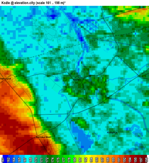
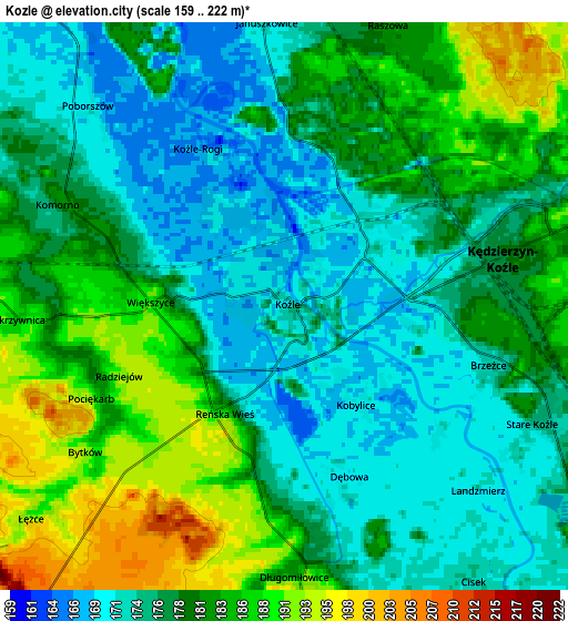
| \ | Map #1 | Map #2 | Topo.Map |
| Scale [m] | 161..198 m | 159..222 m | × |
| Scale [ft] | 528..650 ft | 522..728 ft | × |
| Average | 172.3 m = 565 ft | 179 m = 587 ft | × |
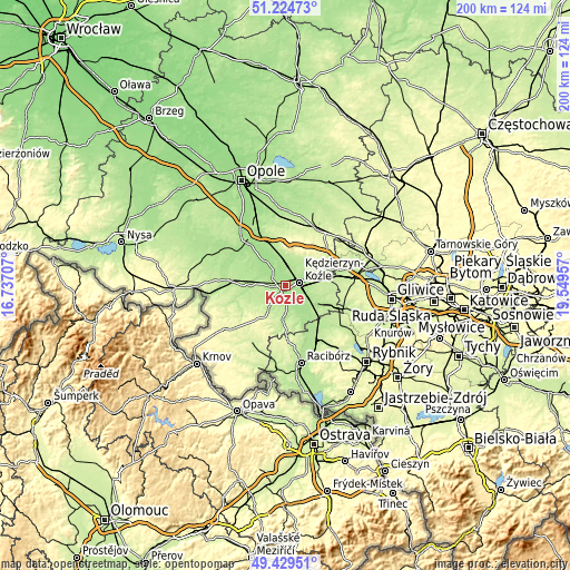
| Width | 6.24 km = 3.9 mi | 12.48 km = 7.8 mi | 199.6 km = 124 mi |
| Height | 6.24 km = 3.9 mi | 12.48 km = 7.8 mi | 199.6 km = 124 mi |
| ↑Max Latitude | 50.363642° | 50.391667° | 51.22473° |
| Latitude at center | 50.3356° | 50.3356° | 50.3356° |
| ↓Min Latitude | 50.307542° | 50.279467° | 49.42951° |
| ← Min Longitude | 18.099375° | 18.055429° | 16.73707° |
| Longitude center | 18.14332° | 18.14332° | 18.14332° |
| →Max Longitude | 18.187265° | 18.231211° | 19.54957° |
Nearby cities:
Cities around Koźle sort by population:
• Kędzierzyn-Koźle elevation 182 m
6.1 km,  74°
74°
• Zdzieszowice 185 m
10 km,  351°
351°
• Leśnica 222 m
11 km,  16°
16°
• Walce 182 m
10.7 km,  292°
292°
• Reńska Wieś 181 m
2.5 km,  209°
209°
• Długomiłowice 185 m
5.9 km,  176°
176°
• Cisek 173 m
7.2 km,  145°
145°
• Bierawa 177 m
9.3 km,  130°
130°
• Januszkowice 173 m
6.3 km,  355°
355°
• Większyce 189 m
2.9 km,  272°
272°
• Raszowa 188 m
7.3 km, 19°
• Twardawa 193 m
10.8 km, 274°
Multilingual:
 En español:
Koźle elevación 171 m.
 En France:
Koźle élévation 171 m.


Sources and notes:
- [note 1] Map square and city borders are not equal. Map elevation data is calculated only from area inside that square.
- [src 1] Elevation data from geonames database provided with same terms of usage.
- [src 2] The elevation map of Koźle is generated using elevation data from NASA's 3 arcsec (90m) resolution SRTM data.
- [src 3] Base (background) map © OpenStreetMap contributors tiles are generated by Geofabrik and OpenTopoMap.
Copyright & License:
This Koźle Elevation Map is licensed under CC BY-SA. You may reuse any part from this page, if you give a proper credit by linking to this URL:
 More info on terms of use page.