Kalej elevation
Kalej (Silesia, Powiat kłobucki), Poland elevation is 287 meters and Kalej elevation in feet is 942 ft above sea level [src 1]. Kalej is a populated place (feature code) with elevation that is 96 meters (315 ft) bigger than average city elevation in Poland.
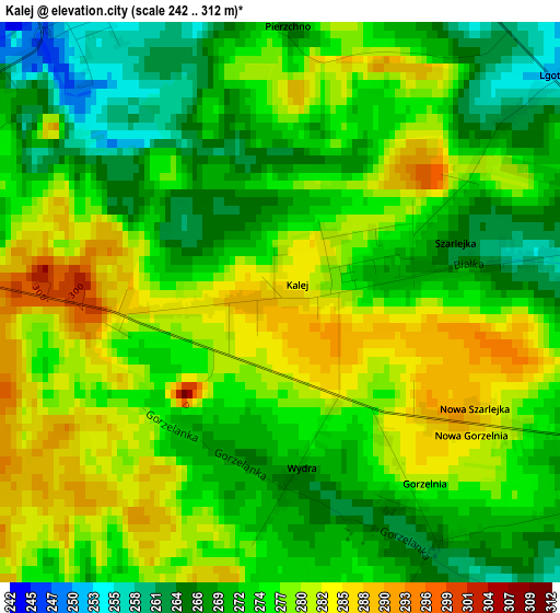
Below is the Elevation map of Kalej, which displays elevation range with different colors. Scale of the first map is from 242 to 312 m (794 to 1024 ft) with average elevation of 275.1 meters (=903 ft) [note 1]
These maps also provides idea of topography and contour of this city, they are displayed at different zoom levels. More info about maps, scale and edge coordinates you can find below images.
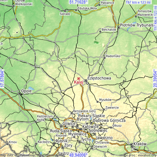
| \ | Map #1 | Topo.Map |
| Scale [m] | 242..312 m | × |
| Scale [ft] | 794..1024 ft | × |
| Average | 275.1 m = 903 ft | × |
| Width | 6.17 km = 3.8 mi | 197.5 km = 122.7 mi |
| Height | 6.17 km = 3.8 mi | 197.5 km = 122.7 mi |
| ↑Max Latitude | 50.864365° | 51.71628° |
| Latitude at center | 50.83662° | 50.83662° |
| ↓Min Latitude | 50.808859° | 49.94006° |
| ← Min Longitude | 18.940345° | 17.57804° |
| Longitude center | 18.98429° | 18.98429° |
| →Max Longitude | 19.028235° | 20.39054° |
Nearby cities:
Cities around Kalej sort by population:
• Częstochowa elevation 253 m
10.8 km,  114°
114°
• Kłobuck 239 m
7.9 km,  334°
334°
• Blachownia 262 m
6.4 km,  192°
192°
• Konopiska 279 m
12.3 km,  172°
172°
• Wręczyca Wielka 275 m
4.6 km,  283°
283°
• Miedzno 223 m
14.8 km,  359°
359°
• Herby 284 m
11.5 km,  216°
216°
• Truskolasy 264 m
11.5 km,  286°
286°
• Huta Stara B 290 m
15.2 km,  136°
136°
• Ostrowy nad Okszą 208 m
16.5 km,  17°
17°
• Łobodno 222 m
10.5 km,  2°
2°
• Kamyk 228 m
7.9 km, 23°
Multilingual:
 En español:
Kalej elevación 287 m.
 En France:
Kalej élévation 287 m.


Sources and notes:
- [note 1] Map square and city borders are not equal. Map elevation data is calculated only from area inside that square.
- [src 1] Elevation data from geonames database provided with same terms of usage.
- [src 2] The elevation map of Kalej is generated using elevation data from NASA's 3 arcsec (90m) resolution SRTM data.
- [src 3] Base (background) map © OpenStreetMap contributors tiles are generated by Geofabrik and OpenTopoMap.
Copyright & License:
This Kalej Elevation Map is licensed under CC BY-SA. You may reuse any part from this page, if you give a proper credit by linking to this URL:
 More info on terms of use page.