Klonowa elevation
Klonowa (Łódź Voivodeship, Powiat sieradzki), Poland elevation is 163 meters and Klonowa elevation in feet is 535 ft above sea level [src 1]. Klonowa is a seat of a third-order administrative division (feature code) with elevation that is 28 meters (92 ft) smaller than average city elevation in Poland.
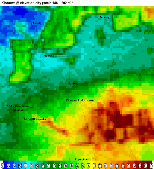
Below is the Elevation map of Klonowa, which displays elevation range with different colors. Scale of the first map is from 146 to 202 m (479 to 663 ft) with average elevation of 170 meters (=558 ft) [note 1]
These maps also provides idea of topography and contour of this city, they are displayed at different zoom levels. More info about maps, scale and edge coordinates you can find below images.
| \ | Map #1 | Topo.Map |
| Scale [m] | 146..202 m | × |
| Scale [ft] | 479..663 ft | × |
| Average | 170 m = 558 ft | × |
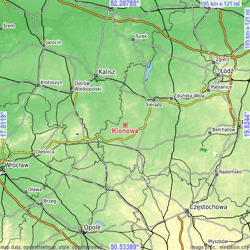
| Width | 6.09 km = 3.8 mi | 195 km = 121.2 mi |
| Height | 6.09 km = 3.8 mi | 195 km = 121.2 mi |
| ↑Max Latitude | 51.446677° | 52.28785° |
| Latitude at center | 51.41928° | 51.41928° |
| ↓Min Latitude | 51.391867° | 50.53389° |
| ← Min Longitude | 18.374205° | 17.0119° |
| Longitude center | 18.41815° | 18.41815° |
| →Max Longitude | 18.462095° | 19.8244° |
Nearby cities:
Cities around Klonowa sort by population:
• Złoczew elevation 181 m
12.9 km,  91°
91°
• Grabów nad Prosną 130 m
22.8 km,  294°
294°
• Kraszewice 131 m
17.6 km,  308°
308°
• Lututów 171 m
5.6 km,  168°
168°
• Czarnożyły 188 m
17.9 km,  146°
146°
• Galewice 160 m
13.9 km,  233°
233°
• Sokolniki 181 m
13.8 km,  205°
205°
• Brzeźnio 169 m
16.4 km,  59°
59°
• Walichnowy 182 m
14 km,  190°
190°
• Czajków 146 m
10.2 km,  322°
322°
• Brąszewice 170 m
9.1 km,  13°
13°
• Czastary 190 m
19.1 km,  200°
200°
Multilingual:
 En español:
Klonowa elevación 163 m.
 En France:
Klonowa élévation 163 m.


Sources and notes:
- [note 1] Map square and city borders are not equal. Map elevation data is calculated only from area inside that square.
- [src 1] Elevation data from geonames database provided with same terms of usage.
- [src 2] The elevation map of Klonowa is generated using elevation data from NASA's 3 arcsec (90m) resolution SRTM data.
- [src 3] Base (background) map © OpenStreetMap contributors tiles are generated by Geofabrik and OpenTopoMap.
Copyright & License:
This Klonowa Elevation Map is licensed under CC BY-SA. You may reuse any part from this page, if you give a proper credit by linking to this URL:
 More info on terms of use page.