Kobiernice elevation
Kobiernice (Silesia, Powiat bielski), Poland elevation is 288 meters and Kobiernice elevation in feet is 945 ft above sea level [src 1]. Kobiernice is a populated place (feature code) with elevation that is 97 meters (318 ft) bigger than average city elevation in Poland.
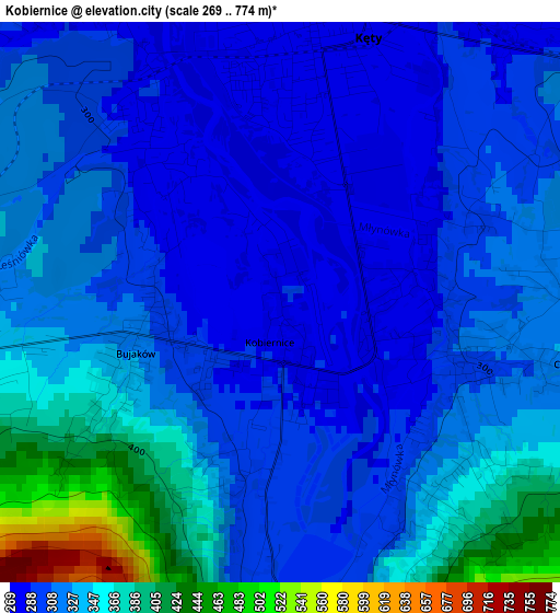
Below is the Elevation map of Kobiernice, which displays elevation range with different colors. Scale of the first map is from 269 to 774 m (883 to 2539 ft) with average elevation of 323.9 meters (=1063 ft) [note 1]
These maps also provides idea of topography and contour of this city, they are displayed at different zoom levels. More info about maps, scale and edge coordinates you can find below images.
| \ | Map #1 | Topo.Map |
| Scale [m] | 269..774 m | × |
| Scale [ft] | 883..2539 ft | × |
| Average | 323.9 m = 1063 ft | × |
| Width | 6.3 km = 3.9 mi | 201.6 km = 125.3 mi |
| Height | 6.3 km = 3.9 mi | 201.6 km = 125.3 mi |
| ↑Max Latitude | 49.883294° | 50.75312° |
| Latitude at center | 49.85497° | 49.85497° |
| ↓Min Latitude | 49.826629° | 48.93981° |
| ← Min Longitude | 19.172515° | 17.81021° |
| Longitude center | 19.21646° | 19.21646° |
| →Max Longitude | 19.260405° | 20.62271° |
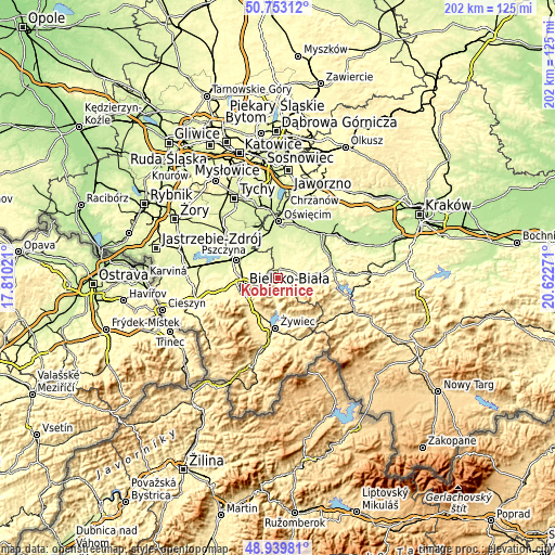
Nearby cities:
Cities around Kobiernice sort by population:
• Kęty elevation 275 m
3.1 km,  9°
9°
• Kozy 386 m
4.9 km,  260°
260°
• Czaniec 320 m
2.7 km,  100°
100°
• Bulowice 299 m
5.7 km,  65°
65°
• Pisarzowice 295 m
6 km,  302°
302°
• Porąbka 311 m
4.2 km,  178°
178°
• Roczyny 345 m
7.1 km,  91°
91°
• Nowa Wieś 266 m
5.8 km,  0°
0°
• Międzybrodzie Bialskie 329 m
7.6 km,  190°
190°
• Bujaków 312 m
1.6 km, 257°
• Witkowice 300 m
7.4 km,  37°
37°
• Malec 270 m
7.6 km,  15°
15°
Multilingual:
 En español:
Kobiernice elevación 288 m.
 En France:
Kobiernice élévation 288 m.
 Auf Deutsch:
Kobiernice höhe über dem Meeresspiegel ist 288 m.

Sources and notes:
- [note 1] Map square and city borders are not equal. Map elevation data is calculated only from area inside that square.
- [src 1] Elevation data from geonames database provided with same terms of usage.
- [src 2] The elevation map of Kobiernice is generated using elevation data from NASA's 3 arcsec (90m) resolution SRTM data.
- [src 3] Base (background) map © OpenStreetMap contributors tiles are generated by Geofabrik and OpenTopoMap.
Copyright & License:
This Kobiernice Elevation Map is licensed under CC BY-SA. You may reuse any part from this page, if you give a proper credit by linking to this URL:
 More info on terms of use page.