Kozy elevation
Kozy (Silesia, Powiat bielski), Poland elevation is 386 meters and Kozy elevation in feet is 1266 ft above sea level [src 1]. Kozy is a populated place (feature code) with elevation that is 195 meters (640 ft) bigger than average city elevation in Poland.
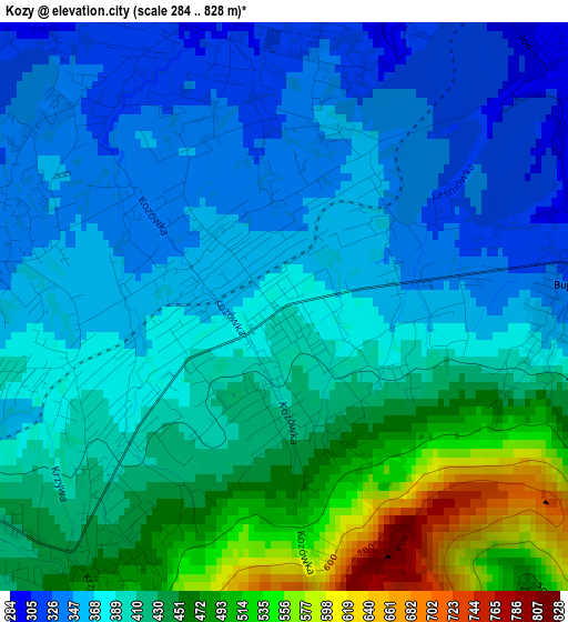
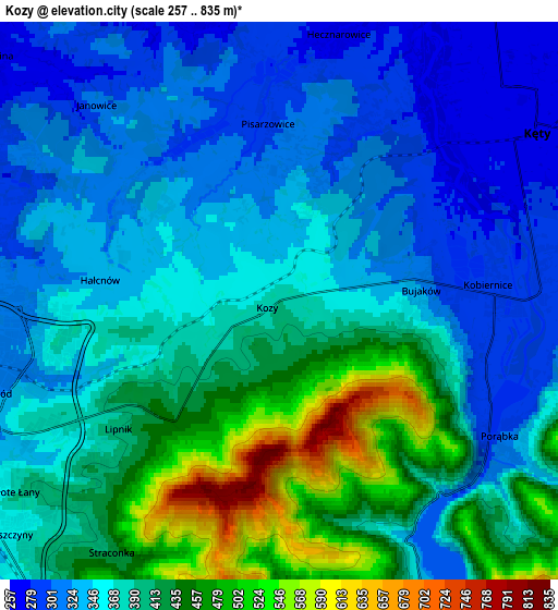
Below is the Elevation map of Kozy, which displays elevation range with different colors. Scale of the first map is from 284 to 828 m (932 to 2717 ft) with average elevation of 403.3 meters (=1323 ft) [note 1]
These maps also provides idea of topography and contour of this city, they are displayed at different zoom levels. More info about maps, scale and edge coordinates you can find below images.
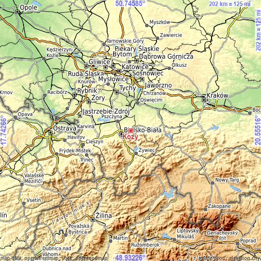
| \ | Map #1 | Map #2 | Topo.Map |
| Scale [m] | 284..828 m | 257..835 m | × |
| Scale [ft] | 932..2717 ft | 843..2740 ft | × |
| Average | 403.3 m = 1323 ft | 378.3 m = 1241 ft | × |
| Width | 6.3 km = 3.9 mi | 12.6 km = 7.8 mi | 201.7 km = 125.3 mi |
| Height | 6.3 km = 3.9 mi | 12.6 km = 7.8 mi | 201.6 km = 125.3 mi |
| ↑Max Latitude | 49.875889° | 49.904201° | 50.74585° |
| Latitude at center | 49.84756° | 49.84756° | 49.84756° |
| ↓Min Latitude | 49.819215° | 49.790853° | 48.93226° |
| ← Min Longitude | 19.104965° | 19.061019° | 17.74266° |
| Longitude center | 19.14891° | 19.14891° | 19.14891° |
| →Max Longitude | 19.192855° | 19.236801° | 20.55516° |
Nearby cities:
Cities around Kozy sort by population:
• Bielsko-Biala elevation 319 m
7.8 km,  249°
249°
• Kęty 275 m
6.6 km,  54°
54°
• Czaniec 320 m
7.5 km,  87°
87°
• Pisarzowice 295 m
4 km,  356°
356°
• Bestwina 262 m
8.5 km,  310°
310°
• Porąbka 311 m
6 km,  124°
124°
• Nowa Wieś 266 m
8.2 km,  36°
36°
• Kobiernice 288 m
4.9 km,  80°
80°
• Międzybrodzie Bialskie 329 m
7.5 km,  152°
152°
• Wilamowice 284 m
7.7 km,  1°
1°
• Bujaków 312 m
3.3 km, 81°
• Janowice 315 m
5.7 km,  316°
316°
Multilingual:
 En español:
Kozy elevación 386 m.
 En France:
Kozy élévation 386 m.


Sources and notes:
- [note 1] Map square and city borders are not equal. Map elevation data is calculated only from area inside that square.
- [src 1] Elevation data from geonames database provided with same terms of usage.
- [src 2] The elevation map of Kozy is generated using elevation data from NASA's 3 arcsec (90m) resolution SRTM data.
- [src 3] Base (background) map © OpenStreetMap contributors tiles are generated by Geofabrik and OpenTopoMap.
Copyright & License:
This Kozy Elevation Map is licensed under CC BY-SA. You may reuse any part from this page, if you give a proper credit by linking to this URL:
 More info on terms of use page.