Koziegłowy elevation
Koziegłowy (Silesia, Powiat myszkowski), Poland elevation is 300 meters and Koziegłowy elevation in feet is 984 ft above sea level [src 1]. Koziegłowy is a seat of a third-order administrative division (feature code) with elevation that is 109 meters (358 ft) bigger than average city elevation in Poland.
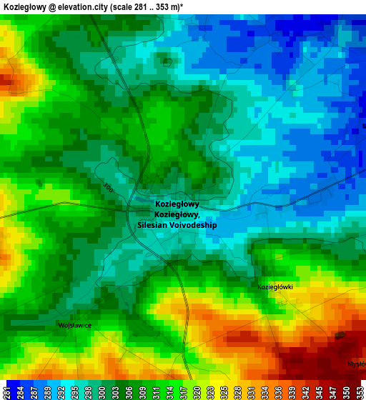
Below is the Elevation map of Koziegłowy, which displays elevation range with different colors. Scale of the first map is from 281 to 353 m (922 to 1158 ft) with average elevation of 306.8 meters (=1007 ft) [note 1]
These maps also provides idea of topography and contour of this city, they are displayed at different zoom levels. More info about maps, scale and edge coordinates you can find below images.
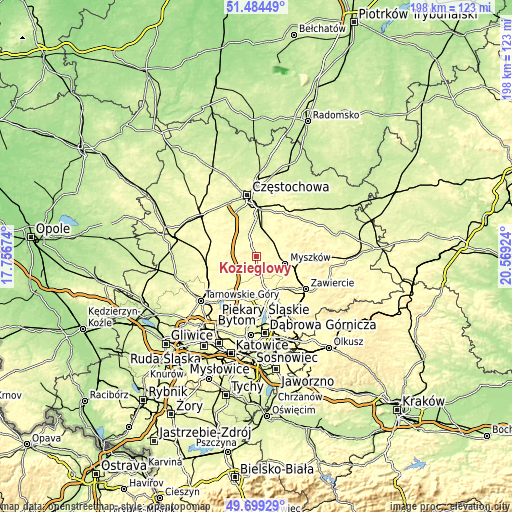
| \ | Map #1 | Topo.Map |
| Scale [m] | 281..353 m | × |
| Scale [ft] | 922..1158 ft | × |
| Average | 306.8 m = 1007 ft | × |
| Width | 6.2 km = 3.9 mi | 198.5 km = 123.3 mi |
| Height | 6.2 km = 3.9 mi | 198.5 km = 123.3 mi |
| ↑Max Latitude | 50.628235° | 51.48449° |
| Latitude at center | 50.60035° | 50.60035° |
| ↓Min Latitude | 50.572449° | 49.69929° |
| ← Min Longitude | 19.119045° | 17.75674° |
| Longitude center | 19.16299° | 19.16299° |
| →Max Longitude | 19.206935° | 20.56924° |
Nearby cities:
Cities around Koziegłowy sort by population:
• Myszków elevation 294 m
11.7 km,  103°
103°
• Wożniki 308 m
7.4 km,  260°
260°
• Poraj 273 m
9.4 km,  23°
23°
• Żarki 333 m
14.4 km,  78°
78°
• Żarki-Letnisko 292 m
8.3 km,  72°
72°
• Kamienica Polska 271 m
8.3 km,  340°
340°
• Psary 311 m
13.7 km,  276°
276°
• Jastrząb 276 m
7.9 km,  9°
9°
• Starcza 285 m
11.1 km,  309°
309°
• Choroń 327 m
11.4 km,  37°
37°
• Cynków 362 m
5.2 km,  215°
215°
• Gniazdów 333 m
3.7 km, 262°
Multilingual:
 En español:
Koziegłowy elevación 300 m.
 En France:
Koziegłowy élévation 300 m.
 Auf Deutsch:
Koziegłowy höhe über dem Meeresspiegel ist 300 m.

Sources and notes:
- [note 1] Map square and city borders are not equal. Map elevation data is calculated only from area inside that square.
- [src 1] Elevation data from geonames database provided with same terms of usage.
- [src 2] The elevation map of Koziegłowy is generated using elevation data from NASA's 3 arcsec (90m) resolution SRTM data.
- [src 3] Base (background) map © OpenStreetMap contributors tiles are generated by Geofabrik and OpenTopoMap.
Copyright & License:
This Koziegłowy Elevation Map is licensed under CC BY-SA. You may reuse any part from this page, if you give a proper credit by linking to this URL:
 More info on terms of use page.