Ligota elevation
Ligota (Silesia, Powiat bielski), Poland elevation is 247 meters and Ligota elevation in feet is 810 ft above sea level [src 1]. Ligota is a populated place (feature code) with elevation that is 56 meters (184 ft) bigger than average city elevation in Poland.
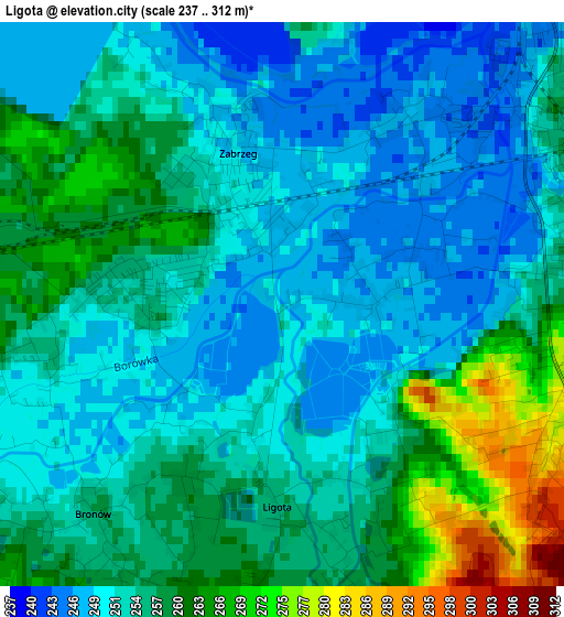
Below is the Elevation map of Ligota, which displays elevation range with different colors. Scale of the first map is from 237 to 312 m (778 to 1024 ft) with average elevation of 255.1 meters (=837 ft) [note 1]
These maps also provides idea of topography and contour of this city, they are displayed at different zoom levels. More info about maps, scale and edge coordinates you can find below images.
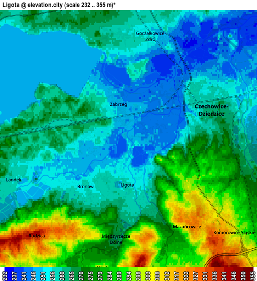
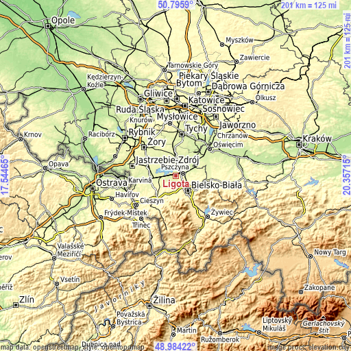
| \ | Map #1 | Map #2 | Topo.Map |
| Scale [m] | 237..312 m | 232..355 m | × |
| Scale [ft] | 778..1024 ft | 761..1165 ft | × |
| Average | 255.1 m = 837 ft | 266.8 m = 875 ft | × |
| Width | 6.29 km = 3.9 mi | 12.59 km = 7.8 mi | 201.4 km = 125.1 mi |
| Height | 6.29 km = 3.9 mi | 12.59 km = 7.8 mi | 201.4 km = 125.1 mi |
| ↑Max Latitude | 49.926859° | 49.955141° | 50.7959° |
| Latitude at center | 49.89856° | 49.89856° | 49.89856° |
| ↓Min Latitude | 49.870245° | 49.841913° | 48.98422° |
| ← Min Longitude | 18.906955° | 18.863009° | 17.54465° |
| Longitude center | 18.9509° | 18.9509° | 18.9509° |
| →Max Longitude | 18.994845° | 19.038791° | 20.35715° |
Nearby cities:
Cities around Ligota sort by population:
• Czechowice-Dziedzice elevation 259 m
4.2 km,  66°
66°
• Pszczyna 242 m
9.1 km,  1°
1°
• Goczałkowice Zdrój 250 m
5.3 km,  14°
14°
• Jasienica 322 m
9.7 km,  192°
192°
• Bestwina 262 m
7.7 km,  91°
91°
• Chybie 258 m
8.8 km,  272°
272°
• Mazańcowice 273 m
4.9 km,  157°
157°
• Zabrzeg 246 m
2 km,  343°
343°
• Kaniów 240 m
8.7 km,  55°
55°
• Janowice 315 m
10.3 km,  98°
98°
• Bestwinka 246 m
9.1 km, 65°
• Bronów 258 m
3.1 km,  222°
222°
Multilingual:
 En español:
Ligota elevación 247 m.
 En France:
Ligota élévation 247 m.


Sources and notes:
- [note 1] Map square and city borders are not equal. Map elevation data is calculated only from area inside that square.
- [src 1] Elevation data from geonames database provided with same terms of usage.
- [src 2] The elevation map of Ligota is generated using elevation data from NASA's 3 arcsec (90m) resolution SRTM data.
- [src 3] Base (background) map © OpenStreetMap contributors tiles are generated by Geofabrik and OpenTopoMap.
Copyright & License:
This Ligota Elevation Map is licensed under CC BY-SA. You may reuse any part from this page, if you give a proper credit by linking to this URL:
 More info on terms of use page.