Linia elevation
Linia (Pomerania, Powiat wejherowski), Poland elevation is 170 meters and Linia elevation in feet is 558 ft above sea level [src 1]. Linia is a populated place (feature code) with elevation that is 21 meters (69 ft) smaller than average city elevation in Poland.
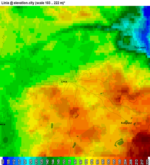
Below is the Elevation map of Linia, which displays elevation range with different colors. Scale of the first map is from 103 to 222 m (338 to 728 ft) with average elevation of 170.4 meters (=559 ft) [note 1]
These maps also provides idea of topography and contour of this city, they are displayed at different zoom levels. More info about maps, scale and edge coordinates you can find below images.
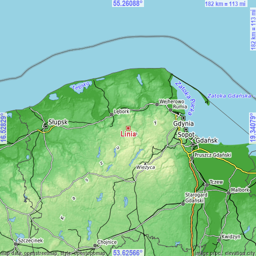
| \ | Map #1 | Topo.Map |
| Scale [m] | 103..222 m | × |
| Scale [ft] | 338..728 ft | × |
| Average | 170.4 m = 559 ft | × |
| Width | 5.68 km = 3.5 mi | 181.8 km = 113 mi |
| Height | 5.68 km = 3.5 mi | 181.8 km = 113 mi |
| ↑Max Latitude | 54.476972° | 55.26088° |
| Latitude at center | 54.45143° | 54.45143° |
| ↓Min Latitude | 54.425873° | 53.62566° |
| ← Min Longitude | 17.890595° | 16.52829° |
| Longitude center | 17.93454° | 17.93454° |
| →Max Longitude | 17.978485° | 19.34079° |
Nearby cities:
Cities around Linia sort by population:
• Lębork elevation 18 m
15.4 km,  309°
309°
• Kartuzy 210 m
21.4 km,  127°
127°
• Sierakowice 215 m
12 km,  193°
193°
• Bolszewo 33 m
24.2 km,  40°
40°
• Luzino 81 m
17 km, 41°
• Gościcino 47 m
22.2 km, 39°
• Nowa Wieś Lęborska 18 m
17.9 km, 311°
• Garcz 169 m
15.8 km,  136°
136°
• Cewice 159 m
13 km,  262°
262°
• Szemud 175 m
19 km,  77°
77°
• Chmielno 172 m
17.6 km, 142°
• Łęczyce 31 m
16.6 km,  342°
342°
Multilingual:
 En español:
Linia elevación 170 m.
 En France:
Linia élévation 170 m.


Sources and notes:
- [note 1] Map square and city borders are not equal. Map elevation data is calculated only from area inside that square.
- [src 1] Elevation data from geonames database provided with same terms of usage.
- [src 2] The elevation map of Linia is generated using elevation data from NASA's 3 arcsec (90m) resolution SRTM data.
- [src 3] Base (background) map © OpenStreetMap contributors tiles are generated by Geofabrik and OpenTopoMap.
Copyright & License:
This Linia Elevation Map is licensed under CC BY-SA. You may reuse any part from this page, if you give a proper credit by linking to this URL:
 More info on terms of use page.