Szemud elevation
Szemud (Pomerania, Powiat wejherowski), Poland elevation is 175 meters and Szemud elevation in feet is 574 ft above sea level [src 1]. Szemud is a seat of a third-order administrative division (feature code) with elevation that is 16 meters (52 ft) smaller than average city elevation in Poland.
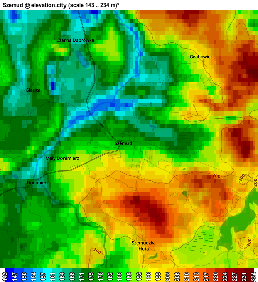
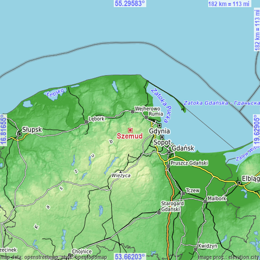
Below is the Elevation map of Szemud, which displays elevation range with different colors. Scale of the first map is from 143 to 234 m (469 to 768 ft) with average elevation of 187.8 meters (=616 ft) [note 1]
These maps also provides idea of topography and contour of this city, they are displayed at different zoom levels. More info about maps, scale and edge coordinates you can find below images.
| \ | Map #1 | Topo.Map |
| Scale [m] | 143..234 m | × |
| Scale [ft] | 469..768 ft | × |
| Average | 187.8 m = 616 ft | × |
| Width | 5.68 km = 3.5 mi | 181.7 km = 112.9 mi |
| Height | 5.68 km = 3.5 mi | 181.6 km = 112.8 mi |
| ↑Max Latitude | 54.512609° | 55.29583° |
| Latitude at center | 54.48709° | 54.48709° |
| ↓Min Latitude | 54.461555° | 53.66203° |
| ← Min Longitude | 18.178855° | 16.81655° |
| Longitude center | 18.2228° | 18.2228° |
| →Max Longitude | 18.266745° | 19.62905° |
Nearby cities:
Cities around Szemud sort by population:
• Wejherowo elevation 27 m
13.2 km,  3°
3°
• Rumia 23 m
14.2 km,  48°
48°
• Reda 7 m
15.4 km,  31°
31°
• Kartuzy 210 m
17.1 km,  185°
185°
• Bolszewo 33 m
14.9 km,  348°
348°
• Luzino 81 m
11.4 km,  320°
320°
• Gościcino 47 m
13.8 km,  341°
341°
• Chwaszczyno 155 m
13.5 km,  110°
110°
• Banino 139 m
15.9 km,  131°
131°
• Bojano 161 m
10.6 km,  99°
99°
• Koleczkowo 151 m
7.8 km,  90°
90°
• Przodkowo 177 m
12.6 km,  160°
160°
Multilingual:
 En español:
Szemud elevación 175 m.
 En France:
Szemud élévation 175 m.


Sources and notes:
- [note 1] Map square and city borders are not equal. Map elevation data is calculated only from area inside that square.
- [src 1] Elevation data from geonames database provided with same terms of usage.
- [src 2] The elevation map of Szemud is generated using elevation data from NASA's 3 arcsec (90m) resolution SRTM data.
- [src 3] Base (background) map © OpenStreetMap contributors tiles are generated by Geofabrik and OpenTopoMap.
Copyright & License:
This Szemud Elevation Map is licensed under CC BY-SA. You may reuse any part from this page, if you give a proper credit by linking to this URL:
 More info on terms of use page.