Lubomierz elevation
Lubomierz (Lower Silesia, Powiat lwówecki), Poland elevation is 360 meters and Lubomierz elevation in feet is 1181 ft above sea level [src 1]. Lubomierz is a seat of a third-order administrative division (feature code) with elevation that is 169 meters (554 ft) bigger than average city elevation in Poland.
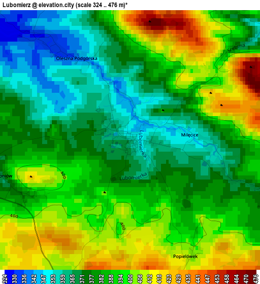
Below is the Elevation map of Lubomierz, which displays elevation range with different colors. Scale of the first map is from 324 to 476 m (1063 to 1562 ft) with average elevation of 386 meters (=1266 ft) [note 1]
These maps also provides idea of topography and contour of this city, they are displayed at different zoom levels. More info about maps, scale and edge coordinates you can find below images.
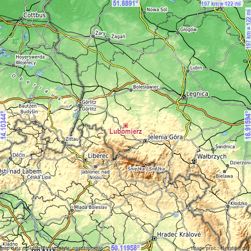
| \ | Map #1 | Topo.Map |
| Scale [m] | 324..476 m | × |
| Scale [ft] | 1063..1562 ft | × |
| Average | 386 m = 1266 ft | × |
| Width | 6.15 km = 3.8 mi | 196.8 km = 122.3 mi |
| Height | 6.15 km = 3.8 mi | 196.7 km = 122.2 mi |
| ↑Max Latitude | 51.04042° | 51.8891° |
| Latitude at center | 51.01278° | 51.01278° |
| ↓Min Latitude | 50.985124° | 50.11958° |
| ← Min Longitude | 15.465745° | 14.10344° |
| Longitude center | 15.50969° | 15.50969° |
| →Max Longitude | 15.553635° | 16.91594° |
Nearby cities:
Cities around Lubomierz sort by population:
• Jelenia Góra elevation 331 m
19.8 km,  129°
129°
• Lubań 221 m
19.6 km,  307°
307°
• Lwówek Śląski 213 m
12.1 km,  26°
26°
• Gryfów Śląski 322 m
6.6 km,  287°
287°
• Piechowice 380 m
19.2 km,  160°
160°
• Olszyna 245 m
11.3 km,  302°
302°
• Leśna 235 m
17.2 km,  274°
274°
• Świeradów-Zdrój 469 m
16.4 km,  225°
225°
• Mirsk 351 m
9.9 km,  241°
241°
• Wleń 230 m
11.6 km,  88°
88°
• Jeżów Sudecki 369 m
18.5 km,  117°
117°
• Stara Kamienica 373 m
11.6 km, 157°
Multilingual:
 En español:
Lubomierz elevación 360 m.
 En France:
Lubomierz élévation 360 m.
 Auf Deutsch:
Lubomierz höhe über dem Meeresspiegel ist 360 m.

Sources and notes:
- [note 1] Map square and city borders are not equal. Map elevation data is calculated only from area inside that square.
- [src 1] Elevation data from geonames database provided with same terms of usage.
- [src 2] The elevation map of Lubomierz is generated using elevation data from NASA's 3 arcsec (90m) resolution SRTM data.
- [src 3] Base (background) map © OpenStreetMap contributors tiles are generated by Geofabrik and OpenTopoMap.
Copyright & License:
This Lubomierz Elevation Map is licensed under CC BY-SA. You may reuse any part from this page, if you give a proper credit by linking to this URL:
 More info on terms of use page.