Mętków elevation
Mętków (Lesser Poland, Powiat chrzanowski), Poland elevation is 229 meters and Mętków elevation in feet is 751 ft above sea level [src 1]. Mętków is a populated place (feature code) with elevation that is 38 meters (125 ft) bigger than average city elevation in Poland.
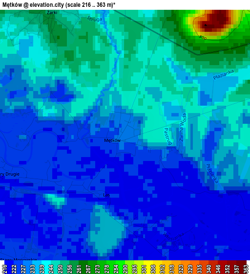
Below is the Elevation map of Mętków, which displays elevation range with different colors. Scale of the first map is from 216 to 363 m (709 to 1191 ft) with average elevation of 235 meters (=771 ft) [note 1]
These maps also provides idea of topography and contour of this city, they are displayed at different zoom levels. More info about maps, scale and edge coordinates you can find below images.
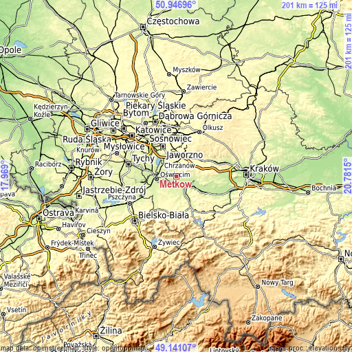
| \ | Map #1 | Topo.Map |
| Scale [m] | 216..363 m | × |
| Scale [ft] | 709..1191 ft | × |
| Average | 235 m = 771 ft | × |
| Width | 6.27 km = 3.9 mi | 200.8 km = 124.8 mi |
| Height | 6.27 km = 3.9 mi | 200.8 km = 124.8 mi |
| ↑Max Latitude | 50.080718° | 50.94696° |
| Latitude at center | 50.05251° | 50.05251° |
| ↓Min Latitude | 50.024285° | 49.14107° |
| ← Min Longitude | 19.331305° | 17.969° |
| Longitude center | 19.37525° | 19.37525° |
| →Max Longitude | 19.419195° | 20.7815° |
Nearby cities:
Cities around Mętków sort by population:
• Libiąż elevation 285 m
7.1 km,  323°
323°
• Zator 242 m
7.7 km,  144°
144°
• Płaza 368 m
8.3 km,  50°
50°
• Przeciszów 231 m
5.1 km,  179°
179°
• Polanka Wielka 249 m
8.3 km,  205°
205°
• Żarki 257 m
3.7 km,  333°
333°
• Zagórze 293 m
5.1 km,  23°
23°
• Poręba Wielka 242 m
8 km,  234°
234°
• Kwaczała 251 m
8.4 km,  81°
81°
• Włosienica 233 m
5.7 km, 227°
• Pogorzyce 358 m
6.4 km,  31°
31°
• Babice 258 m
5.6 km,  71°
71°
Multilingual:
 En español:
Mętków elevación 229 m.
 En France:
Mętków élévation 229 m.


Sources and notes:
- [note 1] Map square and city borders are not equal. Map elevation data is calculated only from area inside that square.
- [src 1] Elevation data from geonames database provided with same terms of usage.
- [src 2] The elevation map of Mętków is generated using elevation data from NASA's 3 arcsec (90m) resolution SRTM data.
- [src 3] Base (background) map © OpenStreetMap contributors tiles are generated by Geofabrik and OpenTopoMap.
Copyright & License:
This Mętków Elevation Map is licensed under CC BY-SA. You may reuse any part from this page, if you give a proper credit by linking to this URL:
 More info on terms of use page.