Przeciszów elevation
Przeciszów (Lesser Poland, Powiat oświęcimski), Poland elevation is 231 meters and Przeciszów elevation in feet is 758 ft above sea level [src 1]. Przeciszów is a populated place (feature code) with elevation that is 40 meters (131 ft) bigger than average city elevation in Poland.
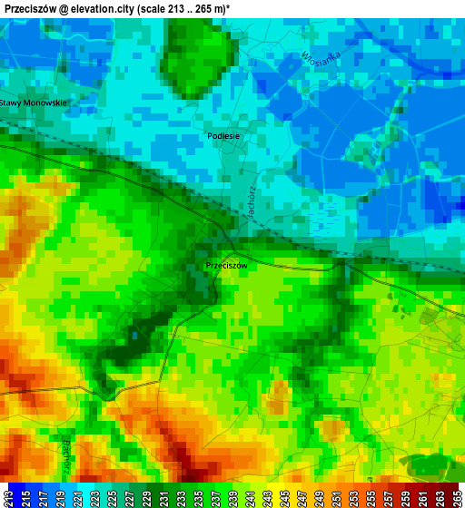
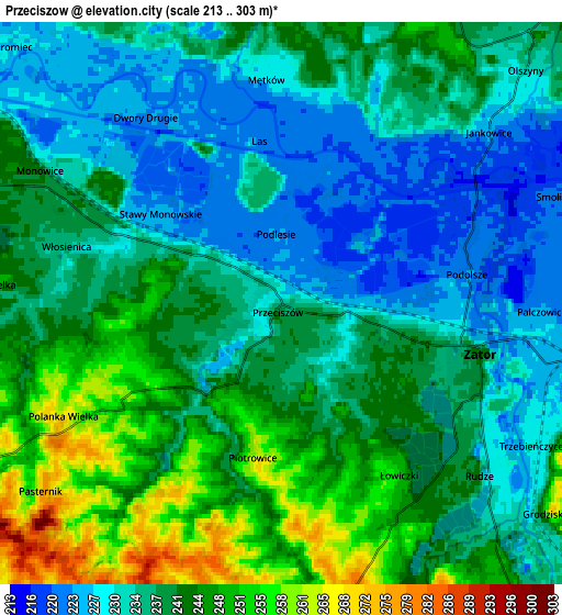
Below is the Elevation map of Przeciszów, which displays elevation range with different colors. Scale of the first map is from 213 to 265 m (699 to 869 ft) with average elevation of 232.5 meters (=763 ft) [note 1]
These maps also provides idea of topography and contour of this city, they are displayed at different zoom levels. More info about maps, scale and edge coordinates you can find below images.
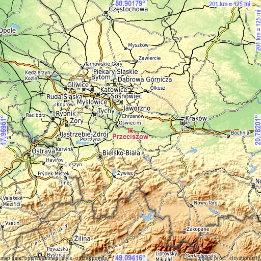
| \ | Map #1 | Map #2 | Topo.Map |
| Scale [m] | 213..265 m | 213..303 m | × |
| Scale [ft] | 699..869 ft | 699..994 ft | × |
| Average | 232.5 m = 763 ft | 237.8 m = 780 ft | × |
| Width | 6.28 km = 3.9 mi | 12.56 km = 7.8 mi | 201 km = 124.9 mi |
| Height | 6.28 km = 3.9 mi | 12.56 km = 7.8 mi | 201 km = 124.9 mi |
| ↑Max Latitude | 50.034705° | 50.062924° | 50.90179° |
| Latitude at center | 50.00647° | 50.00647° | 50.00647° |
| ↓Min Latitude | 49.978218° | 49.949949° | 49.09416° |
| ← Min Longitude | 19.331815° | 19.287869° | 17.96951° |
| Longitude center | 19.37576° | 19.37576° | 19.37576° |
| →Max Longitude | 19.419705° | 19.463651° | 20.78201° |
Nearby cities:
Cities around Przeciszów sort by population:
• Zator elevation 242 m
4.6 km,  104°
104°
• Spytkowice 227 m
9.7 km, 96°
• Polanka Wielka 249 m
4.3 km,  236°
236°
• Żarki 257 m
8.6 km,  348°
348°
• Zagórze 293 m
10 km,  11°
11°
• Zaborze 243 m
9.8 km,  279°
279°
• Bachowice 298 m
10 km,  122°
122°
• Poręba Wielka 242 m
6.6 km,  274°
274°
• Włosienica 233 m
4.4 km,  287°
287°
• Mętków 229 m
5.1 km,  359°
359°
• Babice 258 m
8.7 km,  37°
37°
• Gierałtowice 296 m
7 km,  171°
171°
Multilingual:
 En español:
Przeciszów elevación 231 m.
 En France:
Przeciszów élévation 231 m.
 Auf Deutsch:
Przeciszów höhe über dem Meeresspiegel ist 231 m.

Sources and notes:
- [note 1] Map square and city borders are not equal. Map elevation data is calculated only from area inside that square.
- [src 1] Elevation data from geonames database provided with same terms of usage.
- [src 2] The elevation map of Przeciszów is generated using elevation data from NASA's 3 arcsec (90m) resolution SRTM data.
- [src 3] Base (background) map © OpenStreetMap contributors tiles are generated by Geofabrik and OpenTopoMap.
Copyright & License:
This Przeciszów Elevation Map is licensed under CC BY-SA. You may reuse any part from this page, if you give a proper credit by linking to this URL:
 More info on terms of use page.