Oława elevation
Oława (Lower Silesia, Powiat oławski), Poland elevation is 129 meters and Oława elevation in feet is 423 ft above sea level [src 1]. Oława is a populated place (feature code) with elevation that is 62 meters (203 ft) smaller than average city elevation in Poland.
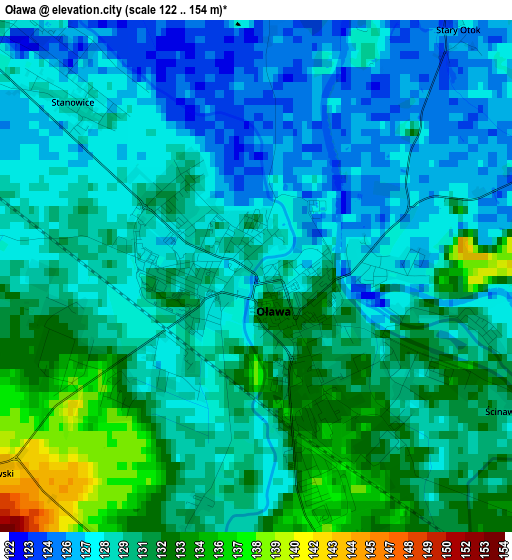
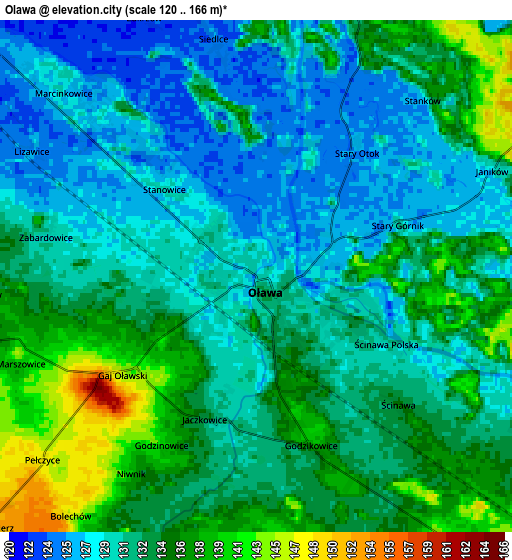
Below is the Elevation map of Oława, which displays elevation range with different colors. Scale of the first map is from 122 to 154 m (400 to 505 ft) with average elevation of 129.5 meters (=425 ft) [note 1]
These maps also provides idea of topography and contour of this city, they are displayed at different zoom levels. More info about maps, scale and edge coordinates you can find below images.
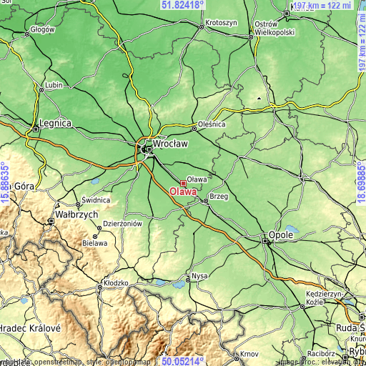
| \ | Map #1 | Map #2 | Topo.Map |
| Scale [m] | 122..154 m | 120..166 m | × |
| Scale [ft] | 400..505 ft | 394..545 ft | × |
| Average | 129.5 m = 425 ft | 132.2 m = 434 ft | × |
| Width | 6.16 km = 3.8 mi | 12.31 km = 7.6 mi | 197 km = 122.4 mi |
| Height | 6.16 km = 3.8 mi | 12.31 km = 7.6 mi | 197 km = 122.4 mi |
| ↑Max Latitude | 50.974279° | 51.001942° | 51.82418° |
| Latitude at center | 50.9466° | 50.9466° | 50.9466° |
| ↓Min Latitude | 50.918904° | 50.891192° | 50.05214° |
| ← Min Longitude | 17.248655° | 17.204709° | 15.88635° |
| Longitude center | 17.2926° | 17.2926° | 17.2926° |
| →Max Longitude | 17.336545° | 17.380491° | 18.69885° |
Nearby cities:
Cities around Oława sort by population:
• Brzeg elevation 147 m
15.5 km,  127°
127°
• Jelcz Laskowice 128 m
8.5 km,  11°
11°
• Jelcz 128 m
8.5 km, 13°
• Siechnice 120 m
14 km,  313°
313°
• Wiązów 152 m
16.1 km,  203°
203°
• Bystrzyca 142 m
7.5 km,  78°
78°
• Święta Katarzyna 126 m
15.3 km, 305°
• Kamieniec Wrocławski 118 m
15.9 km,  330°
330°
• Skarbimierz Osiedle 154 m
14.3 km,  141°
141°
• Czernica 126 m
11.6 km,  343°
343°
• Ratowice 129 m
9.7 km,  351°
351°
• Wierzbno 140 m
8 km,  262°
262°
Multilingual:
 En español:
Oława elevación 129 m.
 En France:
Oława élévation 129 m.


Sources and notes:
- [note 1] Map square and city borders are not equal. Map elevation data is calculated only from area inside that square.
- [src 1] Elevation data from geonames database provided with same terms of usage.
- [src 2] The elevation map of Oława is generated using elevation data from NASA's 3 arcsec (90m) resolution SRTM data.
- [src 3] Base (background) map © OpenStreetMap contributors tiles are generated by Geofabrik and OpenTopoMap.
Copyright & License:
This Oława Elevation Map is licensed under CC BY-SA. You may reuse any part from this page, if you give a proper credit by linking to this URL:
 More info on terms of use page.