Wiązów elevation
Wiązów (Lower Silesia, Powiat strzeliński), Poland elevation is 152 meters and Wiązów elevation in feet is 499 ft above sea level [src 1]. Wiązów is a populated place (feature code) with elevation that is 39 meters (128 ft) smaller than average city elevation in Poland.
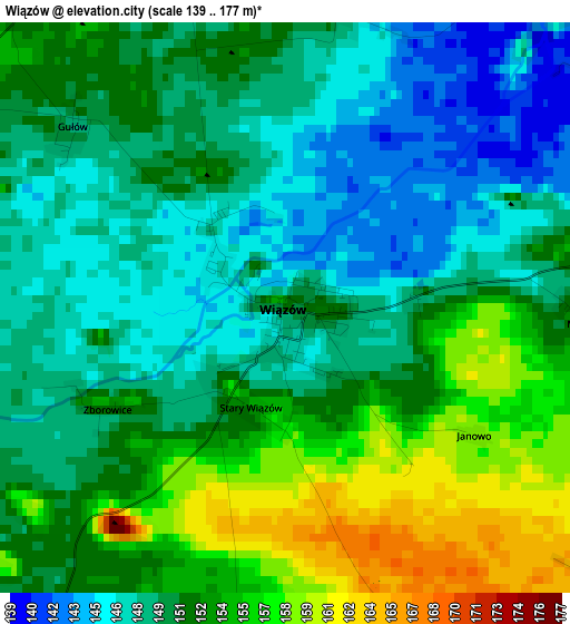
Below is the Elevation map of Wiązów, which displays elevation range with different colors. Scale of the first map is from 139 to 177 m (456 to 581 ft) with average elevation of 150.9 meters (=495 ft) [note 1]
These maps also provides idea of topography and contour of this city, they are displayed at different zoom levels. More info about maps, scale and edge coordinates you can find below images.
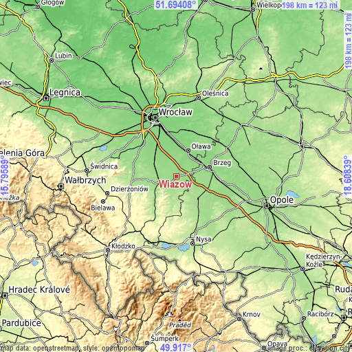
| \ | Map #1 | Topo.Map |
| Scale [m] | 139..177 m | × |
| Scale [ft] | 456..581 ft | × |
| Average | 150.9 m = 495 ft | × |
| Width | 6.17 km = 3.8 mi | 197.6 km = 122.8 mi |
| Height | 6.17 km = 3.8 mi | 197.6 km = 122.8 mi |
| ↑Max Latitude | 50.841748° | 51.69408° |
| Latitude at center | 50.81399° | 50.81399° |
| ↓Min Latitude | 50.786215° | 49.917° |
| ← Min Longitude | 17.158195° | 15.79589° |
| Longitude center | 17.20214° | 17.20214° |
| →Max Longitude | 17.246085° | 18.60839° |
Nearby cities:
Cities around Wiązów sort by population:
• Brzeg elevation 147 m
19.3 km,  74°
74°
• Oława 129 m
16.1 km,  23°
23°
• Strzelin 164 m
10.3 km,  249°
249°
• Grodków 172 m
18.2 km,  135°
135°
• Henryków 208 m
22.4 km,  217°
217°
• Bystrzyca 142 m
21.3 km,  40°
40°
• Żórawina 130 m
21.9 km,  327°
327°
• Skarbimierz Osiedle 154 m
15.6 km,  76°
76°
• Przeworno 188 m
14.4 km,  190°
190°
• Wierzbno 140 m
13.7 km,  353°
353°
• Jordanów Śląski 154 m
24.1 km,  283°
283°
• Olszanka 159 m
19.6 km,  96°
96°
Multilingual:
 En español:
Wiązów elevación 152 m.
 En France:
Wiązów élévation 152 m.


Sources and notes:
- [note 1] Map square and city borders are not equal. Map elevation data is calculated only from area inside that square.
- [src 1] Elevation data from geonames database provided with same terms of usage.
- [src 2] The elevation map of Wiązów is generated using elevation data from NASA's 3 arcsec (90m) resolution SRTM data.
- [src 3] Base (background) map © OpenStreetMap contributors tiles are generated by Geofabrik and OpenTopoMap.
Copyright & License:
This Wiązów Elevation Map is licensed under CC BY-SA. You may reuse any part from this page, if you give a proper credit by linking to this URL:
 More info on terms of use page.