Paczków elevation
Paczków (Opole Voivodeship, Powiat nyski), Poland elevation is 229 meters and Paczków elevation in feet is 751 ft above sea level [src 1]. Paczków is a seat of a third-order administrative division (feature code) with elevation that is 38 meters (125 ft) bigger than average city elevation in Poland.
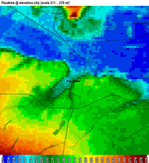
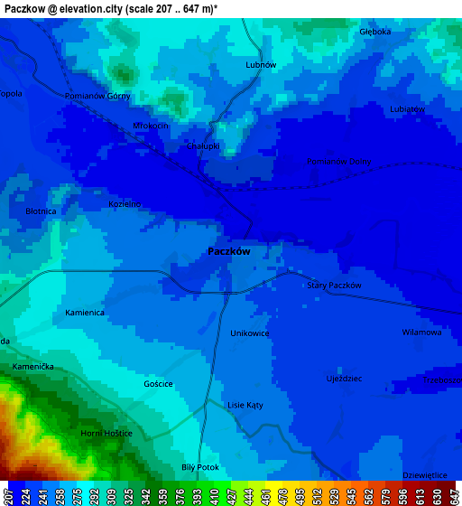
Below is the Elevation map of Paczków, which displays elevation range with different colors. Scale of the first map is from 211 to 279 m (692 to 915 ft) with average elevation of 234 meters (=768 ft) [note 1]
These maps also provides idea of topography and contour of this city, they are displayed at different zoom levels. More info about maps, scale and edge coordinates you can find below images.
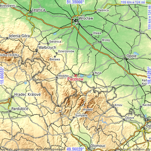
| \ | Map #1 | Map #2 | Topo.Map |
| Scale [m] | 211..279 m | 207..647 m | × |
| Scale [ft] | 692..915 ft | 679..2123 ft | × |
| Average | 234 m = 768 ft | 255.3 m = 838 ft | × |
| Width | 6.22 km = 3.9 mi | 12.44 km = 7.7 mi | 199.1 km = 123.7 mi |
| Height | 6.22 km = 3.9 mi | 12.44 km = 7.7 mi | 199.1 km = 123.7 mi |
| ↑Max Latitude | 50.491916° | 50.519865° | 51.35066° |
| Latitude at center | 50.46395° | 50.46395° | 50.46395° |
| ↓Min Latitude | 50.435968° | 50.407969° | 49.56029° |
| ← Min Longitude | 16.962635° | 16.918689° | 15.60033° |
| Longitude center | 17.00658° | 17.00658° | 17.00658° |
| →Max Longitude | 17.050525° | 17.094471° | 18.41283° |
Nearby cities:
Cities around Paczków sort by population:
• Nysa elevation 191 m
23.2 km,  87°
87°
• Ząbkowice Śląskie 287 m
19.6 km,  315°
315°
• Ziębice 220 m
15.5 km,  8°
8°
• Stronie Śląskie 493 m
21 km,  206°
206°
• Lądek-Zdrój 434 m
16.1 km, 213°
• Otmuchów 208 m
11.8 km, 88°
• Kamieniec Ząbkowicki 241 m
11.3 km,  307°
307°
• Henryków 208 m
21.1 km,  0°
0°
• Złoty Stok 350 m
9.5 km,  256°
256°
• Bardo 278 m
19.4 km,  283°
283°
• Kamienica 261 m
4 km,  247°
247°
• Kamiennik 247 m
15.6 km,  40°
40°
Multilingual:
 En español:
Paczków elevación 229 m.
 En France:
Paczków élévation 229 m.


Sources and notes:
- [note 1] Map square and city borders are not equal. Map elevation data is calculated only from area inside that square.
- [src 1] Elevation data from geonames database provided with same terms of usage.
- [src 2] The elevation map of Paczków is generated using elevation data from NASA's 3 arcsec (90m) resolution SRTM data.
- [src 3] Base (background) map © OpenStreetMap contributors tiles are generated by Geofabrik and OpenTopoMap.
Copyright & License:
This Paczków Elevation Map is licensed under CC BY-SA. You may reuse any part from this page, if you give a proper credit by linking to this URL:
 More info on terms of use page.