Wielowieś elevation
Wielowieś (Silesia, Powiat gliwicki), Poland elevation is 262 meters and Wielowieś elevation in feet is 860 ft above sea level [src 1]. Wielowieś is a populated place (feature code) with elevation that is 71 meters (233 ft) bigger than average city elevation in Poland.
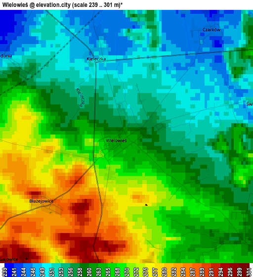
Below is the Elevation map of Wielowieś, which displays elevation range with different colors. Scale of the first map is from 239 to 301 m (784 to 988 ft) with average elevation of 262.6 meters (=862 ft) [note 1]
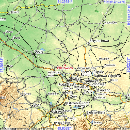
These maps also provides idea of topography and contour of this city, they are displayed at different zoom levels. More info about maps, scale and edge coordinates you can find below images.
| \ | Map #1 | Topo.Map |
| Scale [m] | 239..301 m | × |
| Scale [ft] | 784..988 ft | × |
| Average | 262.6 m = 862 ft | × |
| Width | 6.21 km = 3.9 mi | 198.9 km = 123.6 mi |
| Height | 6.21 km = 3.9 mi | 198.9 km = 123.6 mi |
| ↑Max Latitude | 50.537599° | 51.39551° |
| Latitude at center | 50.50966° | 50.50966° |
| ↓Min Latitude | 50.481705° | 49.60687° |
| ← Min Longitude | 18.572135° | 17.20983° |
| Longitude center | 18.61608° | 18.61608° |
| →Max Longitude | 18.660025° | 20.02233° |
Nearby cities:
Cities around Wielowieś sort by population:
• Tarnowskie Góry elevation 297 m
18.8 km,  112°
112°
• Lubliniec 258 m
18.4 km,  15°
15°
• Pyskowice 232 m
12.3 km,  174°
174°
• Kalety 271 m
20.4 km,  73°
73°
• Zawadzkie 212 m
14.1 km,  318°
318°
• Toszek 255 m
9.1 km,  227°
227°
• Tworóg 248 m
7.4 km, 71°
• Jemielnica 215 m
17.3 km,  283°
283°
• Krupski Młyn 232 m
7.1 km,  3°
3°
• Zbrosławice 252 m
14.3 km,  136°
136°
• Wieszowa 275 m
17.2 km, 143°
• Pawonków 261 m
20.8 km,  353°
353°
Multilingual:
 En español:
Wielowieś elevación 262 m.
 En France:
Wielowieś élévation 262 m.
 Auf Deutsch:
Wielowieś höhe über dem Meeresspiegel ist 262 m.

Sources and notes:
- [note 1] Map square and city borders are not equal. Map elevation data is calculated only from area inside that square.
- [src 1] Elevation data from geonames database provided with same terms of usage.
- [src 2] The elevation map of Wielowieś is generated using elevation data from NASA's 3 arcsec (90m) resolution SRTM data.
- [src 3] Base (background) map © OpenStreetMap contributors tiles are generated by Geofabrik and OpenTopoMap.
Copyright & License:
This Wielowieś Elevation Map is licensed under CC BY-SA. You may reuse any part from this page, if you give a proper credit by linking to this URL:
 More info on terms of use page.