Wieluń elevation
Wieluń (Łódź Voivodeship, Powiat wieluński), Poland elevation is 180 meters and Wieluń elevation in feet is 591 ft above sea level [src 1]. Wieluń is a populated place (feature code) with elevation that is 11 meters (36 ft) smaller than average city elevation in Poland.
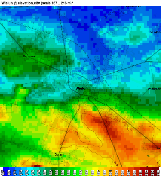
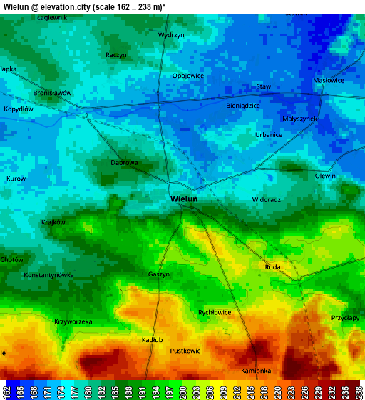
Below is the Elevation map of Wieluń, which displays elevation range with different colors. Scale of the first map is from 167 to 216 m (548 to 709 ft) with average elevation of 184.1 meters (=604 ft) [note 1]
These maps also provides idea of topography and contour of this city, they are displayed at different zoom levels. More info about maps, scale and edge coordinates you can find below images.
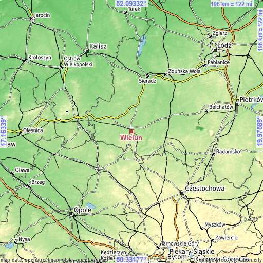
| \ | Map #1 | Map #2 | Topo.Map |
| Scale [m] | 167..216 m | 162..238 m | × |
| Scale [ft] | 548..709 ft | 531..781 ft | × |
| Average | 184.1 m = 604 ft | 187.6 m = 615 ft | × |
| Width | 6.12 km = 3.8 mi | 12.24 km = 7.6 mi | 195.9 km = 121.7 mi |
| Height | 6.12 km = 3.8 mi | 12.24 km = 7.6 mi | 195.9 km = 121.7 mi |
| ↑Max Latitude | 51.248486° | 51.275985° | 52.09332° |
| Latitude at center | 51.22097° | 51.22097° | 51.22097° |
| ↓Min Latitude | 51.193438° | 51.16589° | 50.33177° |
| ← Min Longitude | 18.525695° | 18.481749° | 17.16339° |
| Longitude center | 18.56964° | 18.56964° | 18.56964° |
| →Max Longitude | 18.613585° | 18.657531° | 19.97589° |
Nearby cities:
Cities around Wieluń sort by population:
• Wierzchlas elevation 205 m
6.9 km,  105°
105°
• Skomlin 185 m
13.9 km,  246°
246°
• Mokrsko 212 m
7.3 km,  230°
230°
• Lututów 171 m
19.1 km,  330°
330°
• Pątnów 211 m
9.2 km,  159°
159°
• Czarnożyły 188 m
7.2 km,  355°
355°
• Dalachów 199 m
16 km,  177°
177°
• Osjaków 162 m
17.2 km,  63°
63°
• Sokolniki 181 m
19.1 km,  300°
300°
• Walichnowy 182 m
15.6 km, 302°
• Czastary 190 m
17.9 km,  283°
283°
• Ożarów 239 m
9.4 km,  205°
205°
Multilingual:
 En español:
Wieluń elevación 180 m.
 En France:
Wieluń élévation 180 m.


Sources and notes:
- [note 1] Map square and city borders are not equal. Map elevation data is calculated only from area inside that square.
- [src 1] Elevation data from geonames database provided with same terms of usage.
- [src 2] The elevation map of Wieluń is generated using elevation data from NASA's 3 arcsec (90m) resolution SRTM data.
- [src 3] Base (background) map © OpenStreetMap contributors tiles are generated by Geofabrik and OpenTopoMap.
Copyright & License:
This Wieluń Elevation Map is licensed under CC BY-SA. You may reuse any part from this page, if you give a proper credit by linking to this URL:
 More info on terms of use page.