Złotniki elevation
Złotniki (Greater Poland, Powiat poznański), Poland elevation is 103 meters and Złotniki elevation in feet is 338 ft above sea level [src 1]. Złotniki is a populated place (feature code) with elevation that is 88 meters (289 ft) smaller than average city elevation in Poland.
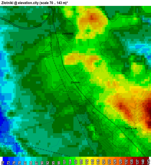
Below is the Elevation map of Złotniki, which displays elevation range with different colors. Scale of the first map is from 70 to 143 m (230 to 469 ft) with average elevation of 98 meters (=322 ft) [note 1]
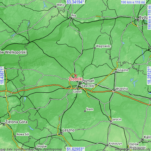
These maps also provides idea of topography and contour of this city, they are displayed at different zoom levels. More info about maps, scale and edge coordinates you can find below images.
| \ | Map #1 | Topo.Map |
| Scale [m] | 70..143 m | × |
| Scale [ft] | 230..469 ft | × |
| Average | 98 m = 322 ft | × |
| Width | 5.95 km = 3.7 mi | 190.4 km = 118.3 mi |
| Height | 5.95 km = 3.7 mi | 190.4 km = 118.3 mi |
| ↑Max Latitude | 52.520818° | 53.34194° |
| Latitude at center | 52.49407° | 52.49407° |
| ↓Min Latitude | 52.467306° | 51.62953° |
| ← Min Longitude | 16.801015° | 15.43871° |
| Longitude center | 16.84496° | 16.84496° |
| →Max Longitude | 16.888905° | 18.25121° |
Nearby cities:
Cities around Złotniki sort by population:
• Poznań elevation 69 m
11.3 km,  149°
149°
• Luboń 60 m
16.7 km,  168°
168°
• Oborniki 58 m
17.2 km,  353°
353°
• Murowana Goślina 78 m
14.3 km,  51°
51°
• Plewiska 82 m
14.3 km,  189°
189°
• Czerwonak 61 m
9.8 km,  109°
109°
• Suchy Las 102 m
3.2 km,  136°
136°
• Tarnowo Podgórne 97 m
12.7 km,  255°
255°
• Rokietnica 89 m
7 km,  286°
286°
• Kobylnica 89 m
16.6 km, 108°
• Baranowo 90 m
7.7 km,  211°
211°
• Pamiątkowo 77 m
12.9 km,  300°
300°
Multilingual:
 En español:
Złotniki elevación 103 m.
 En France:
Złotniki élévation 103 m.
 Auf Deutsch:
Złotniki höhe über dem Meeresspiegel ist 103 m.

Sources and notes:
- [note 1] Map square and city borders are not equal. Map elevation data is calculated only from area inside that square.
- [src 1] Elevation data from geonames database provided with same terms of usage.
- [src 2] The elevation map of Złotniki is generated using elevation data from NASA's 3 arcsec (90m) resolution SRTM data.
- [src 3] Base (background) map © OpenStreetMap contributors tiles are generated by Geofabrik and OpenTopoMap.
Copyright & License:
This Złotniki Elevation Map is licensed under CC BY-SA. You may reuse any part from this page, if you give a proper credit by linking to this URL:
 More info on terms of use page.