Zubrzyca Dolna elevation
Zubrzyca Dolna (Lesser Poland, Powiat nowotarski), Poland elevation is 664 meters and Zubrzyca Dolna elevation in feet is 2178 ft above sea level [src 1]. Zubrzyca Dolna is a populated place (feature code) with elevation that is 473 meters (1552 ft) bigger than average city elevation in Poland.
Below is the Elevation map of Zubrzyca Dolna, which displays elevation range with different colors. Scale of the first map is from 625 to 862 m (2051 to 2828 ft) with average elevation of 702.2 meters (=2304 ft) [note 1]
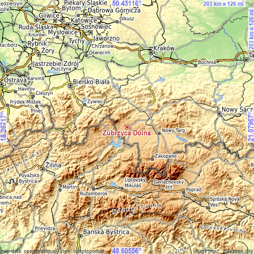
These maps also provides idea of topography and contour of this city, they are displayed at different zoom levels. More info about maps, scale and edge coordinates you can find below images.
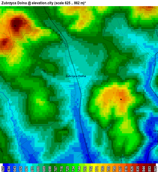
| \ | Map #1 | Topo.Map |
| Scale [m] | 625..862 m | × |
| Scale [ft] | 2051..2828 ft | × |
| Average | 702.2 m = 2304 ft | × |
| Width | 6.34 km = 3.9 mi | 203 km = 126.1 mi |
| Height | 6.34 km = 3.9 mi | 203 km = 126.1 mi |
| ↑Max Latitude | 49.555396° | 50.43116° |
| Latitude at center | 49.52688° | 49.52688° |
| ↓Min Latitude | 49.498347° | 48.60556° |
| ← Min Longitude | 19.629475° | 18.26717° |
| Longitude center | 19.67342° | 19.67342° |
| →Max Longitude | 19.717365° | 21.07967° |
Nearby cities:
Cities around Zubrzyca Dolna sort by population:
• Jabłonka elevation 617 m
5.4 km,  164°
164°
• Raba Wyżna 522 m
15.5 km,  73°
73°
• Lipnica Wielka 620 m
6.4 km,  203°
203°
• Spytkowice 522 m
12.8 km,  64°
64°
• Sidzina 585 m
7.7 km,  20°
20°
• Zubrzyca Górna 720 m
4.2 km,  336°
336°
• Bystra 446 m
15.5 km,  29°
29°
• Lipnica Mała 664 m
3.1 km,  244°
244°
• Podwilk 673 m
5.2 km, 63°
• Piekielnik 646 m
8.8 km,  129°
129°
• Toporzysko 484 m
14.3 km,  40°
40°
• Chyżne 651 m
11.1 km,  181°
181°
Multilingual:
 En español:
Zubrzyca Dolna elevación 664 m.
 En France:
Zubrzyca Dolna élévation 664 m.
 Auf Deutsch:
Zubrzyca Dolna höhe über dem Meeresspiegel ist 664 m.

Sources and notes:
- [note 1] Map square and city borders are not equal. Map elevation data is calculated only from area inside that square.
- [src 1] Elevation data from geonames database provided with same terms of usage.
- [src 2] The elevation map of Zubrzyca Dolna is generated using elevation data from NASA's 3 arcsec (90m) resolution SRTM data.
- [src 3] Base (background) map © OpenStreetMap contributors tiles are generated by Geofabrik and OpenTopoMap.
Copyright & License:
This Zubrzyca Dolna Elevation Map is licensed under CC BY-SA. You may reuse any part from this page, if you give a proper credit by linking to this URL:
 More info on terms of use page.