Spytkowice elevation
Spytkowice (Lesser Poland, Powiat nowotarski), Poland elevation is 522 meters and Spytkowice elevation in feet is 1713 ft above sea level [src 1]. Spytkowice is a seat of a third-order administrative division (feature code) with elevation that is 331 meters (1086 ft) bigger than average city elevation in Poland.
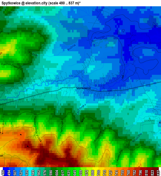
Below is the Elevation map of Spytkowice, which displays elevation range with different colors. Scale of the first map is from 480 to 837 m (1575 to 2746 ft) with average elevation of 582.9 meters (=1912 ft) [note 1]
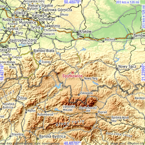
These maps also provides idea of topography and contour of this city, they are displayed at different zoom levels. More info about maps, scale and edge coordinates you can find below images.
| \ | Map #1 | Topo.Map |
| Scale [m] | 480..837 m | × |
| Scale [ft] | 1575..2746 ft | × |
| Average | 582.9 m = 1912 ft | × |
| Width | 6.34 km = 3.9 mi | 202.8 km = 126 mi |
| Height | 6.34 km = 3.9 mi | 202.8 km = 126 mi |
| ↑Max Latitude | 49.605927° | 50.48078° |
| Latitude at center | 49.57744° | 49.57744° |
| ↓Min Latitude | 49.548937° | 48.65707° |
| ← Min Longitude | 19.789465° | 18.42716° |
| Longitude center | 19.83341° | 19.83341° |
| →Max Longitude | 19.877355° | 21.23966° |
Nearby cities:
Cities around Spytkowice sort by population:
• Rabka-Zdrój elevation 494 m
10.2 km,  69°
69°
• Jordanów 497 m
8 km,  358°
358°
• Raba Wyżna 522 m
3.5 km,  109°
109°
• Sidzina 585 m
8.9 km,  280°
280°
• Osielec 466 m
12.1 km,  342°
342°
• Bystra 446 m
8.7 km,  333°
333°
• Podwilk 673 m
7.6 km,  244°
244°
• Piekielnik 646 m
12.1 km,  202°
202°
• Naprawa 534 m
8.4 km,  23°
23°
• Sieniawa 625 m
8.2 km,  121°
121°
• Toporzysko 484 m
5.7 km, 336°
• Rokiciny 569 m
6.5 km,  94°
94°
Multilingual:
 En español:
Spytkowice elevación 522 m.
 En France:
Spytkowice élévation 522 m.
 Auf Deutsch:
Spytkowice höhe über dem Meeresspiegel ist 522 m.

Sources and notes:
- [note 1] Map square and city borders are not equal. Map elevation data is calculated only from area inside that square.
- [src 1] Elevation data from geonames database provided with same terms of usage.
- [src 2] The elevation map of Spytkowice is generated using elevation data from NASA's 3 arcsec (90m) resolution SRTM data.
- [src 3] Base (background) map © OpenStreetMap contributors tiles are generated by Geofabrik and OpenTopoMap.
Copyright & License:
This Spytkowice Elevation Map is licensed under CC BY-SA. You may reuse any part from this page, if you give a proper credit by linking to this URL:
 More info on terms of use page.