Kasur elevation
Kasur (Punjab), Pakistan elevation is 213 meters and Kasur elevation in feet is 699 ft above sea level [src 1]. Kasur is a seat of a second-order administrative division (feature code) with elevation that is 133 meters (436 ft) smaller than average city elevation in Pakistan.
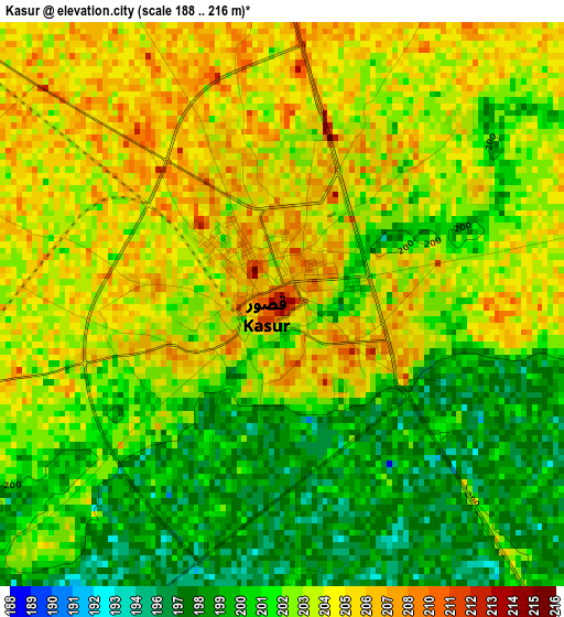
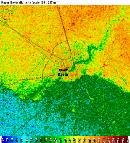
Below is the Elevation map of Kasur, which displays elevation range with different colors. Scale of the first map is from 188 to 216 m (617 to 709 ft) with average elevation of 202.6 meters (=665 ft) [note 1]
These maps also provides idea of topography and contour of this city, they are displayed at different zoom levels. More info about maps, scale and edge coordinates you can find below images.
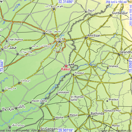
| \ | Map #1 | Map #2 | Topo.Map |
| Scale [m] | 188..216 m | 188..217 m | × |
| Scale [ft] | 617..709 ft | 617..712 ft | × |
| Average | 202.6 m = 665 ft | 202.2 m = 663 ft | × |
| Width | 8.37 km = 5.2 mi | 16.73 km = 10.4 mi | 267.7 km = 166.3 mi |
| Height | 8.37 km = 5.2 mi | 16.73 km = 10.4 mi | 267.7 km = 166.3 mi |
| ↑Max Latitude | 31.156274° | 31.193873° | 32.31486° |
| Latitude at center | 31.11866° | 31.11866° | 31.11866° |
| ↓Min Latitude | 31.081031° | 31.043387° | 29.90719° |
| ← Min Longitude | 74.406305° | 74.362359° | 73.044° |
| Longitude center | 74.45025° | 74.45025° | 74.45025° |
| →Max Longitude | 74.494195° | 74.538141° | 75.8565° |
Nearby cities:
Cities around Kasur sort by population:
• Lahore elevation 216 m
49.8 km,  349°
349°
• Mianke Mor 200 m
48.6 km,  281°
281°
• Pattoki 197 m
57.9 km,  259°
259°
• Hujra Shah Muqim 183 m
73 km,  234°
234°
• Chunian 195 m
48 km,  249°
249°
• Kot Radha Kishan 208 m
33.7 km, 279°
• Kahna Nau 211 m
28.7 km,  344°
344°
• Sharqpur Sharif 211 m
50.5 km,  318°
318°
• Raiwind 209 m
26.6 km,  302°
302°
• Raja Jang 213 m
21.8 km, 301°
• Chak Five Hundred Seventy-five 202 m
75.7 km,  308°
308°
• Kanganpur 188 m
50.2 km,  218°
218°
Multilingual:
 En español:
Kasur elevación 213 m.
 En France:
Kasur élévation 213 m.


Sources and notes:
- [note 1] Map square and city borders are not equal. Map elevation data is calculated only from area inside that square.
- [src 1] Elevation data from geonames database provided with same terms of usage.
- [src 2] The elevation map of Kasur is generated using elevation data from NASA's 3 arcsec (90m) resolution SRTM data.
- [src 3] Base (background) map © OpenStreetMap contributors tiles are generated by Geofabrik and OpenTopoMap.
Copyright & License:
This Kasur Elevation Map is licensed under CC BY-SA. You may reuse any part from this page, if you give a proper credit by linking to this URL:
 More info on terms of use page.