Kotri elevation
Kotri (Sindh), Pakistan elevation is 25 meters and Kotri elevation in feet is 82 ft above sea level [src 1]. Kotri is a populated place (feature code) with elevation that is 321 meters (1053 ft) smaller than average city elevation in Pakistan.
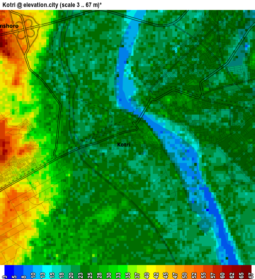
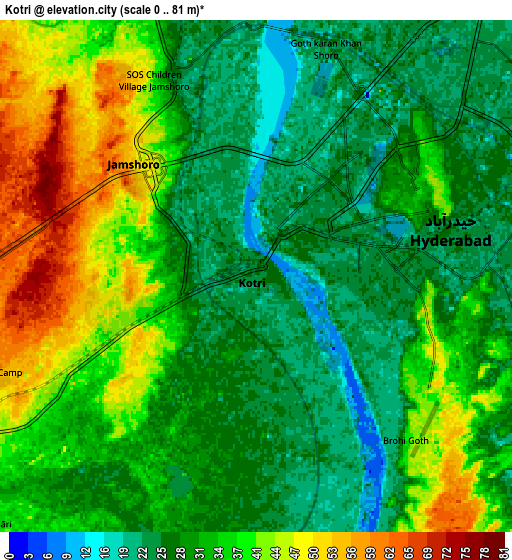
Below is the Elevation map of Kotri, which displays elevation range with different colors. Scale of the first map is from 3 to 67 m (10 to 220 ft) with average elevation of 26 meters (=85 ft) [note 1]
These maps also provides idea of topography and contour of this city, they are displayed at different zoom levels. More info about maps, scale and edge coordinates you can find below images.
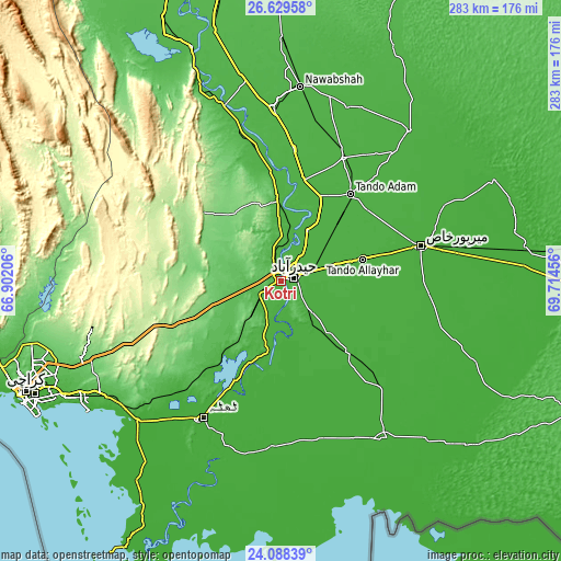
| \ | Map #1 | Map #2 | Topo.Map |
| Scale [m] | 3..67 m | 0..81 m | × |
| Scale [ft] | 10..220 ft | 0..266 ft | × |
| Average | 26 m = 85 ft | 32.8 m = 108 ft | × |
| Width | 8.83 km = 5.5 mi | 17.66 km = 11 mi | 282.6 km = 175.6 mi |
| Height | 8.83 km = 5.5 mi | 17.66 km = 11 mi | 282.6 km = 175.6 mi |
| ↑Max Latitude | 25.405362° | 25.445051° | 26.62958° |
| Latitude at center | 25.36566° | 25.36566° | 25.36566° |
| ↓Min Latitude | 25.325945° | 25.286217° | 24.08839° |
| ← Min Longitude | 68.264365° | 68.220419° | 66.90206° |
| Longitude center | 68.30831° | 68.30831° | 68.30831° |
| →Max Longitude | 68.352255° | 68.396201° | 69.71456° |
Nearby cities:
Cities around Kotri sort by population:
• Hyderabad elevation 40 m
7.2 km,  65°
65°
• Tando Allahyar 23 m
42.4 km,  75°
75°
• Tando Adam 29 m
57.1 km,  38°
38°
• Tando Muhammad Khan 24 m
35.4 km,  139°
139°
• Matli 20 m
50.1 km, 135°
• Hala 30 m
51.2 km,  12°
12°
• Tando Jam 24 m
23.3 km, 72°
• Bhit Shah 31 m
52.3 km,  20°
20°
• Matiari 36 m
29.2 km,  28°
28°
• Chamber 20 m
51.2 km,  98°
98°
• Bulri 11 m
55.5 km,  177°
177°
• Jamshoro 27 m
8.3 km,  340°
340°
Multilingual:
 En español:
Kotri elevación 25 m.
 En France:
Kotri élévation 25 m.


Sources and notes:
- [note 1] Map square and city borders are not equal. Map elevation data is calculated only from area inside that square.
- [src 1] Elevation data from geonames database provided with same terms of usage.
- [src 2] The elevation map of Kotri is generated using elevation data from NASA's 3 arcsec (90m) resolution SRTM data.
- [src 3] Base (background) map © OpenStreetMap contributors tiles are generated by Geofabrik and OpenTopoMap.
Copyright & License:
This Kotri Elevation Map is licensed under CC BY-SA. You may reuse any part from this page, if you give a proper credit by linking to this URL:
 More info on terms of use page.