Mithi elevation
Mithi (Sindh), Pakistan elevation is 38 meters and Mithi elevation in feet is 125 ft above sea level [src 1]. Mithi is a populated place (feature code) with elevation that is 308 meters (1010 ft) smaller than average city elevation in Pakistan.
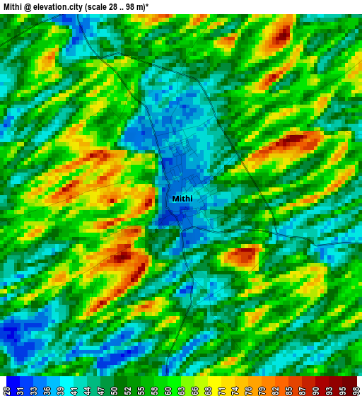
Below is the Elevation map of Mithi, which displays elevation range with different colors. Scale of the first map is from 28 to 98 m (92 to 322 ft) with average elevation of 54.5 meters (=179 ft) [note 1]
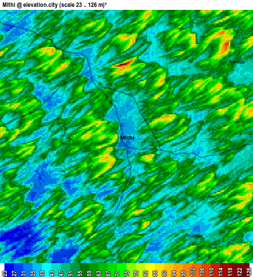
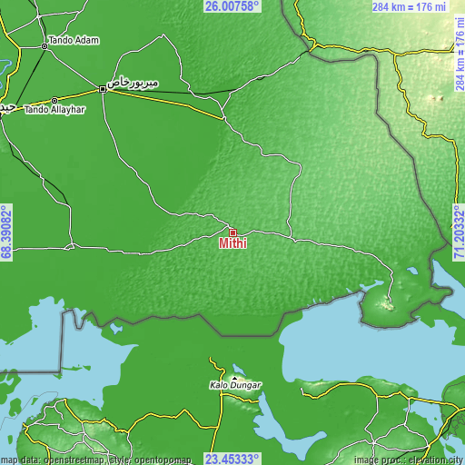
These maps also provides idea of topography and contour of this city, they are displayed at different zoom levels. More info about maps, scale and edge coordinates you can find below images.
| \ | Map #1 | Map #2 | Topo.Map |
| Scale [m] | 28..98 m | 23..126 m | × |
| Scale [ft] | 92..322 ft | 75..413 ft | × |
| Average | 54.5 m = 179 ft | 54.1 m = 177 ft | × |
| Width | 8.88 km = 5.5 mi | 17.75 km = 11 mi | 284 km = 176.5 mi |
| Height | 8.88 km = 5.5 mi | 17.75 km = 11 mi | 284 km = 176.5 mi |
| ↑Max Latitude | 24.776916° | 24.81681° | 26.00758° |
| Latitude at center | 24.73701° | 24.73701° | 24.73701° |
| ↓Min Latitude | 24.697091° | 24.657159° | 23.45333° |
| ← Min Longitude | 69.753125° | 69.709179° | 68.39082° |
| Longitude center | 69.79707° | 69.79707° | 69.79707° |
| →Max Longitude | 69.841015° | 69.884961° | 71.20332° |
Nearby cities:
Cities around Mithi sort by population:
• Umarkot elevation 20 m
69.9 km,  355°
355°
• Digri 18 m
83.4 km,  303°
303°
• Kunri 14 m
54.4 km,  334°
334°
• Naukot 14 m
42.1 km,  288°
288°
• Dhoro Naro 17 m
88.4 km,  345°
345°
• Chhor 6 m
86.2 km, 359°
• Tando Bago 18 m
84.2 km,  273°
273°
• Islamkot 59 m
38.9 km,  96°
96°
• Diplo 12 m
37.1 km,  216°
216°
• Samaro 18 m
72.8 km, 326°
• Kadhan 6 m
86.9 km,  250°
250°
• Nabisar 16 m
39.8 km,  337°
337°
Multilingual:
 En español:
Mithi elevación 38 m.
 En France:
Mithi élévation 38 m.


Sources and notes:
- [note 1] Map square and city borders are not equal. Map elevation data is calculated only from area inside that square.
- [src 1] Elevation data from geonames database provided with same terms of usage.
- [src 2] The elevation map of Mithi is generated using elevation data from NASA's 3 arcsec (90m) resolution SRTM data.
- [src 3] Base (background) map © OpenStreetMap contributors tiles are generated by Geofabrik and OpenTopoMap.
Copyright & License:
This Mithi Elevation Map is licensed under CC BY-SA. You may reuse any part from this page, if you give a proper credit by linking to this URL:
 More info on terms of use page.