Talamba elevation
Talamba (Punjab), Pakistan elevation is 149 meters and Talamba elevation in feet is 489 ft above sea level [src 1]. Talamba is a populated place (feature code) with elevation that is 197 meters (646 ft) smaller than average city elevation in Pakistan.
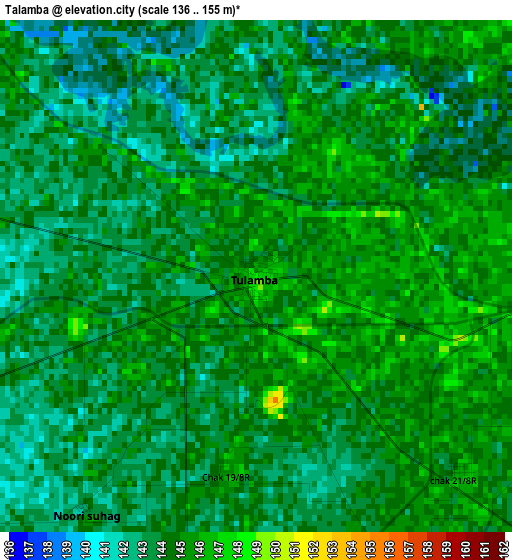
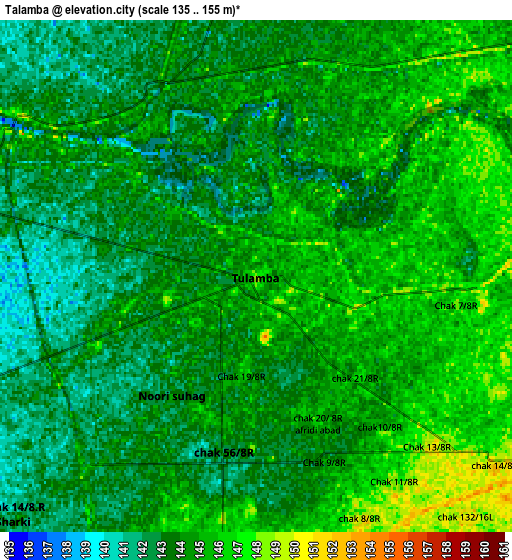
Below is the Elevation map of Talamba, which displays elevation range with different colors. Scale of the first map is from 136 to 155 m (446 to 509 ft) with average elevation of 143.8 meters (=472 ft) [note 1]
These maps also provides idea of topography and contour of this city, they are displayed at different zoom levels. More info about maps, scale and edge coordinates you can find below images.
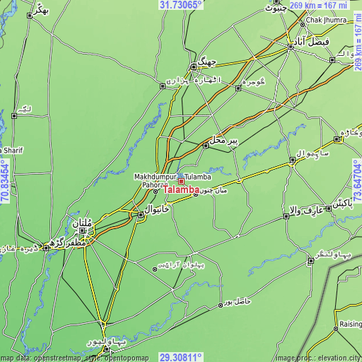
| \ | Map #1 | Map #2 | Topo.Map |
| Scale [m] | 136..155 m | 135..155 m | × |
| Scale [ft] | 446..509 ft | 443..509 ft | × |
| Average | 143.8 m = 472 ft | 143.9 m = 472 ft | × |
| Width | 8.42 km = 5.2 mi | 16.84 km = 10.5 mi | 269.4 km = 167.4 mi |
| Height | 8.42 km = 5.2 mi | 16.84 km = 10.5 mi | 269.4 km = 167.4 mi |
| ↑Max Latitude | 30.564777° | 30.602609° | 31.73065° |
| Latitude at center | 30.52693° | 30.52693° | 30.52693° |
| ↓Min Latitude | 30.489069° | 30.451192° | 29.30811° |
| ← Min Longitude | 72.196845° | 72.152899° | 70.83454° |
| Longitude center | 72.24079° | 72.24079° | 72.24079° |
| →Max Longitude | 72.284735° | 72.328681° | 73.64704° |
Nearby cities:
Cities around Talamba sort by population:
• Vihari elevation 140 m
54.8 km,  168°
168°
• Kamalia 160 m
44.7 km,  60°
60°
• Chichawatni 165 m
43.2 km,  89°
89°
• Mian Channun 154 m
14.7 km,  130°
130°
• Toba Tek Singh 161 m
54.5 km,  25°
25°
• Kabirwala 138 m
38.7 km,  249°
249°
• Chak Thirty-one -Eleven Left 154 m
45.2 km,  104°
104°
• Pir Mahal 158 m
32.5 km, 34°
• Garh Maharaja 143 m
46.9 km,  316°
316°
• Ahmadpur Sial 133 m
50.5 km,  289°
289°
• Sarai Sidhu 143 m
27 km, 286°
• Khanewal 138 m
38.8 km,  229°
229°
Multilingual:
 En español:
Talamba elevación 149 m.
 En France:
Talamba élévation 149 m.


Sources and notes:
- [note 1] Map square and city borders are not equal. Map elevation data is calculated only from area inside that square.
- [src 1] Elevation data from geonames database provided with same terms of usage.
- [src 2] The elevation map of Talamba is generated using elevation data from NASA's 3 arcsec (90m) resolution SRTM data.
- [src 3] Base (background) map © OpenStreetMap contributors tiles are generated by Geofabrik and OpenTopoMap.
Copyright & License:
This Talamba Elevation Map is licensed under CC BY-SA. You may reuse any part from this page, if you give a proper credit by linking to this URL:
 More info on terms of use page.