Yeban Norte elevation
Yeban Norte (Cagayan Valley, Province of Isabela), Philippines elevation is 56 meters and Yeban Norte elevation in feet is 184 ft above sea level [src 1]. Yeban Norte is a populated place (feature code) with elevation that is 32 meters (105 ft) smaller than average city elevation in Philippines.
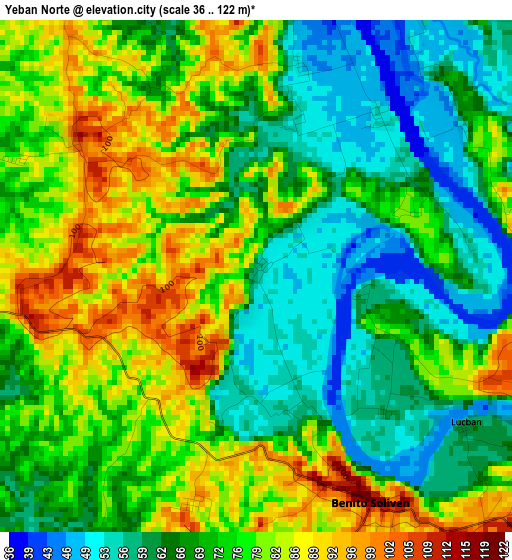
Below is the Elevation map of Yeban Norte, which displays elevation range with different colors. Scale of the first map is from 36 to 122 m (118 to 400 ft) with average elevation of 72.6 meters (=238 ft) [note 1]
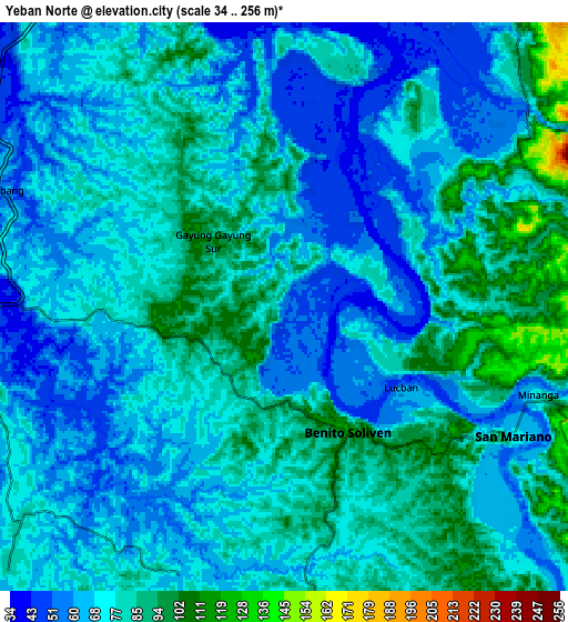
These maps also provides idea of topography and contour of this city, they are displayed at different zoom levels. More info about maps, scale and edge coordinates you can find below images.
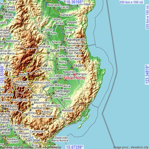
| \ | Map #1 | Map #2 | Topo.Map |
| Scale [m] | 36..122 m | 34..256 m | × |
| Scale [ft] | 118..400 ft | 112..840 ft | × |
| Average | 72.6 m = 238 ft | 74.2 m = 243 ft | × |
| Width | 9.34 km = 5.8 mi | 18.69 km = 11.6 mi | 299 km = 185.8 mi |
| Height | 9.34 km = 5.8 mi | 18.69 km = 11.6 mi | 299 km = 185.8 mi |
| ↑Max Latitude | 17.063965° | 17.105971° | 18.36165° |
| Latitude at center | 17.02195° | 17.02195° | 17.02195° |
| ↓Min Latitude | 16.979925° | 16.937891° | 15.67259° |
| ← Min Longitude | 121.897995° | 121.854049° | 120.53569° |
| Longitude center | 121.94194° | 121.94194° | 121.94194° |
| →Max Longitude | 121.985885° | 122.029831° | 123.34819° |
Nearby cities:
Cities around Yeban Norte sort by population:
• San Mariano elevation 74 m
8.8 km,  119°
119°
• Naguilian 50 m
11.2 km,  270°
270°
• Reina Mercedes 52 m
12.9 km,  251°
251°
• Upi 48 m
13.3 km,  300°
300°
• Gamu 48 m
11.7 km,  285°
285°
• Benito Soliven 106 m
4.9 km,  156°
156°
• Alibago 42 m
13.2 km,  322°
322°
• Maluno Sur 61 m
3.5 km,  137°
137°
• Minallo 68 m
10.1 km, 247°
• Sindon 74 m
8.9 km,  61°
61°
• Daragutan 76 m
10 km,  104°
104°
• San Luis 50 m
13.7 km,  242°
242°
Multilingual:
 En español:
Yeban Norte elevación 56 m.
 En France:
Yeban Norte élévation 56 m.
 Auf Deutsch:
Yeban Norte höhe über dem Meeresspiegel ist 56 m.

Sources and notes:
- [note 1] Map square and city borders are not equal. Map elevation data is calculated only from area inside that square.
- [src 1] Elevation data from geonames database provided with same terms of usage.
- [src 2] The elevation map of Yeban Norte is generated using elevation data from NASA's 3 arcsec (90m) resolution SRTM data.
- [src 3] Base (background) map © OpenStreetMap contributors tiles are generated by Geofabrik and OpenTopoMap.
Copyright & License:
This Yeban Norte Elevation Map is licensed under CC BY-SA. You may reuse any part from this page, if you give a proper credit by linking to this URL:
 More info on terms of use page.