Kapaya elevation
Kapaya (Soccsksargen, Province of Sultan Kudarat), Philippines elevation is 122 meters and Kapaya elevation in feet is 400 ft above sea level [src 1]. Kapaya is a populated place (feature code) with elevation that is 34 meters (112 ft) bigger than average city elevation in Philippines.
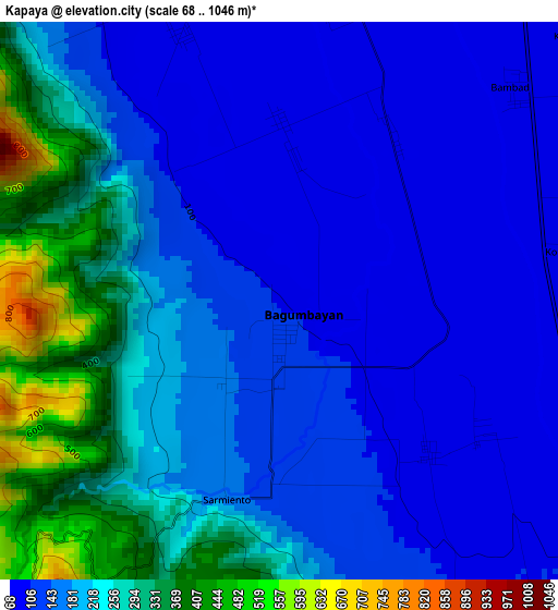
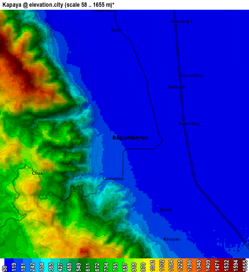
Below is the Elevation map of Kapaya, which displays elevation range with different colors. Scale of the first map is from 68 to 1046 m (223 to 3432 ft) with average elevation of 190.7 meters (=626 ft) [note 1]
These maps also provides idea of topography and contour of this city, they are displayed at different zoom levels. More info about maps, scale and edge coordinates you can find below images.
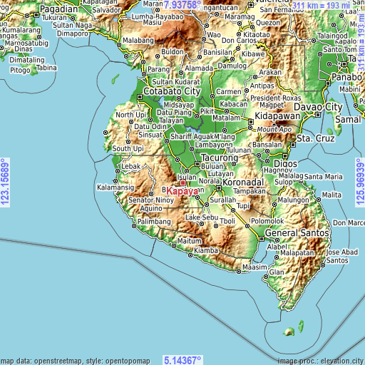
| \ | Map #1 | Map #2 | Topo.Map |
| Scale [m] | 68..1046 m | 58..1655 m | × |
| Scale [ft] | 223..3432 ft | 190..5430 ft | × |
| Average | 190.7 m = 626 ft | 360.2 m = 1182 ft | × |
| Width | 9.71 km = 6 mi | 19.42 km = 12.1 mi | 310.7 km = 193.1 mi |
| Height | 9.71 km = 6 mi | 19.42 km = 12.1 mi | 310.7 km = 193.1 mi |
| ↑Max Latitude | 6.586237° | 6.629891° | 7.93758° |
| Latitude at center | 6.54258° | 6.54258° | 6.54258° |
| ↓Min Latitude | 6.498919° | 6.455254° | 5.14367° |
| ← Min Longitude | 124.519195° | 124.475249° | 123.15689° |
| Longitude center | 124.56314° | 124.56314° | 124.56314° |
| →Max Longitude | 124.607085° | 124.651031° | 125.96939° |
Nearby cities:
Cities around Kapaya sort by population:
• Isulan elevation 65 m
10.7 km,  25°
25°
• Norala 103 m
10.8 km,  101°
101°
• Dansuli 61 m
11.1 km,  11°
11°
• Panay 104 m
9.7 km,  121°
121°
• Tuka 95 m
3.8 km,  134°
134°
• Daguma 79 m
6.8 km, 6°
• Kudanding 76 m
9.2 km,  56°
56°
• Busok 106 m
5.6 km, 133°
• Liberty 91 m
8 km,  108°
108°
• Lapuz 99 m
9.2 km, 125°
• Kolumbug 94 m
5.4 km, 112°
• Biwang 89 m
7.4 km,  342°
342°
Multilingual:
 En español:
Kapaya elevación 122 m.
 En France:
Kapaya élévation 122 m.


Sources and notes:
- [note 1] Map square and city borders are not equal. Map elevation data is calculated only from area inside that square.
- [src 1] Elevation data from geonames database provided with same terms of usage.
- [src 2] The elevation map of Kapaya is generated using elevation data from NASA's 3 arcsec (90m) resolution SRTM data.
- [src 3] Base (background) map © OpenStreetMap contributors tiles are generated by Geofabrik and OpenTopoMap.
Copyright & License:
This Kapaya Elevation Map is licensed under CC BY-SA. You may reuse any part from this page, if you give a proper credit by linking to this URL:
 More info on terms of use page.