Mangusu elevation
Mangusu (Zamboanga Peninsula, Province of Zamboanga del Sur), Philippines elevation is 116 meters and Mangusu elevation in feet is 381 ft above sea level [src 1]. Mangusu is a populated place (feature code) with elevation that is 28 meters (92 ft) bigger than average city elevation in Philippines.
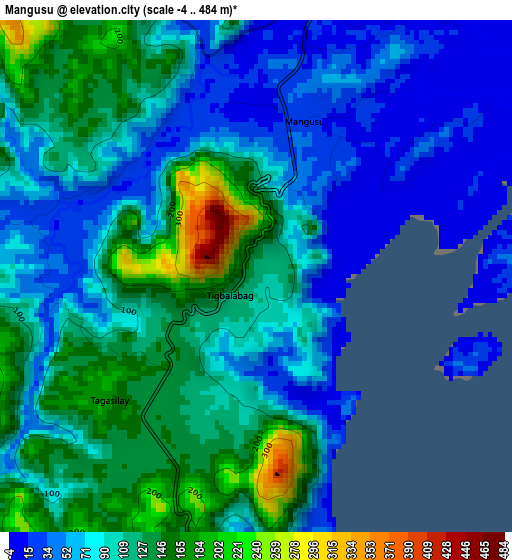
Below is the Elevation map of Mangusu, which displays elevation range with different colors. Scale of the first map is from -4 to 484 m (-13 to 1588 ft) with average elevation of 95.9 meters (=315 ft) [note 1]
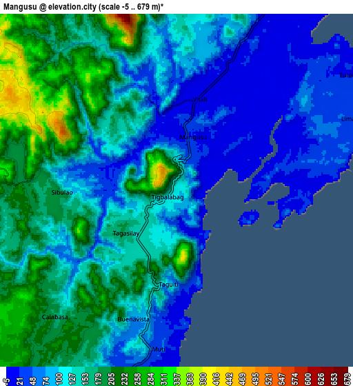
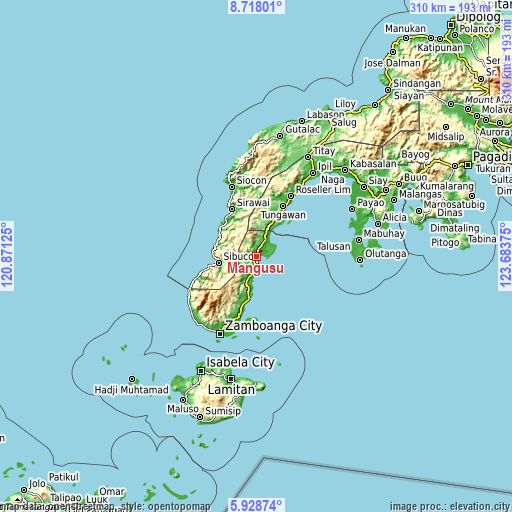
These maps also provides idea of topography and contour of this city, they are displayed at different zoom levels. More info about maps, scale and edge coordinates you can find below images.
| \ | Map #1 | Map #2 | Topo.Map |
| Scale [m] | -4..484 m | -5..679 m | × |
| Scale [ft] | -13..1588 ft | -16..2228 ft | × |
| Average | 95.9 m = 315 ft | 130.4 m = 428 ft | × |
| Width | 9.69 km = 6 mi | 19.39 km = 12 mi | 310.1 km = 192.7 mi |
| Height | 9.69 km = 6 mi | 19.39 km = 12 mi | 310.2 km = 192.7 mi |
| ↑Max Latitude | 7.369144° | 7.412725° | 8.71801° |
| Latitude at center | 7.32556° | 7.32556° | 7.32556° |
| ↓Min Latitude | 7.281971° | 7.238378° | 5.92874° |
| ← Min Longitude | 122.233555° | 122.189609° | 120.87125° |
| Longitude center | 122.2775° | 122.2775° | 122.2775° |
| →Max Longitude | 122.321445° | 122.365391° | 123.68375° |
Nearby cities:
Cities around Mangusu sort by population:
• Vitali elevation 11 m
5.2 km,  13°
13°
• Curuan 15 m
14.2 km,  200°
200°
• Buenavista 49 m
10.2 km,  193°
193°
• Tigpalay 10 m
20.2 km,  21°
21°
• Tungawan 14 m
22.8 km,  26°
26°
• Quinipot 11 m
17.3 km, 201°
• Limaong 33 m
10.5 km,  68°
68°
• Tagasilay 138 m
3.3 km,  219°
219°
• Sibulao 32 m
4.2 km,  267°
267°
• Calabasa 184 m
10 km,  208°
208°
• Muti 22 m
5.5 km,  177°
177°
• Tigbao 19 m
12.7 km, 25°
Multilingual:
 En español:
Mangusu elevación 116 m.
 En France:
Mangusu élévation 116 m.


Sources and notes:
- [note 1] Map square and city borders are not equal. Map elevation data is calculated only from area inside that square.
- [src 1] Elevation data from geonames database provided with same terms of usage.
- [src 2] The elevation map of Mangusu is generated using elevation data from NASA's 3 arcsec (90m) resolution SRTM data.
- [src 3] Base (background) map © OpenStreetMap contributors tiles are generated by Geofabrik and OpenTopoMap.
Copyright & License:
This Mangusu Elevation Map is licensed under CC BY-SA. You may reuse any part from this page, if you give a proper credit by linking to this URL:
 More info on terms of use page.