Tungawan elevation
Tungawan (Zamboanga Peninsula, Province of Zamboanga Sibugay), Philippines elevation is 14 meters and Tungawan elevation in feet is 46 ft above sea level [src 1]. Tungawan is a seat of a third-order administrative division (feature code) with elevation that is 74 meters (243 ft) smaller than average city elevation in Philippines.
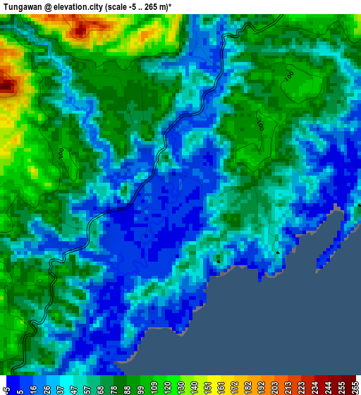
Below is the Elevation map of Tungawan, which displays elevation range with different colors. Scale of the first map is from -5 to 265 m (-16 to 869 ft) with average elevation of 62.4 meters (=205 ft) [note 1]
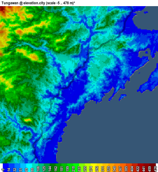
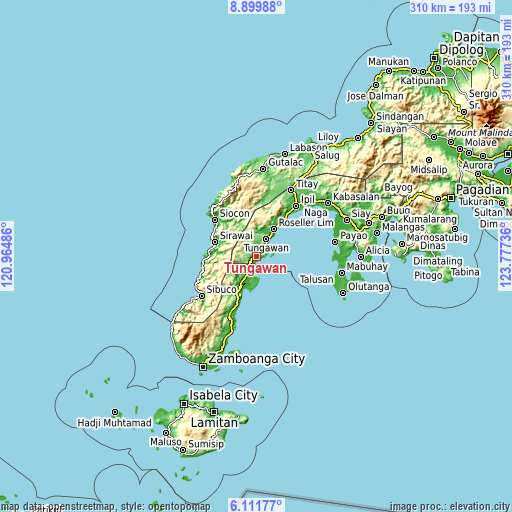
These maps also provides idea of topography and contour of this city, they are displayed at different zoom levels. More info about maps, scale and edge coordinates you can find below images.
| \ | Map #1 | Map #2 | Topo.Map |
| Scale [m] | -5..265 m | -5..478 m | × |
| Scale [ft] | -16..869 ft | -16..1568 ft | × |
| Average | 62.4 m = 205 ft | 103.9 m = 341 ft | × |
| Width | 9.69 km = 6 mi | 19.38 km = 12 mi | 310 km = 192.6 mi |
| Height | 9.69 km = 6 mi | 19.38 km = 12 mi | 310 km = 192.6 mi |
| ↑Max Latitude | 7.551626° | 7.595188° | 8.89988° |
| Latitude at center | 7.50806° | 7.50806° | 7.50806° |
| ↓Min Latitude | 7.464489° | 7.420914° | 6.11177° |
| ← Min Longitude | 122.327165° | 122.283219° | 120.96486° |
| Longitude center | 122.37111° | 122.37111° | 122.37111° |
| →Max Longitude | 122.415055° | 122.459001° | 123.77736° |
Nearby cities:
Cities around Tungawan sort by population:
• Vitali elevation 11 m
17.7 km,  210°
210°
• Buenavista 49 m
32.8 km,  202°
202°
• Tigpalay 10 m
3.2 km,  242°
242°
• Siraway 7 m
26.9 km,  288°
288°
• Mangusu 116 m
22.8 km, 206°
• Limaong 33 m
16.4 km,  181°
181°
• Tagasilay 138 m
26 km, 208°
• Sibulao 32 m
25.1 km,  215°
215°
• Calabasa 184 m
32.8 km, 207°
• Muti 22 m
27.7 km, 201°
• Tigbao 19 m
10.1 km, 208°
• Roseller Lim 18 m
19.6 km,  32°
32°
Multilingual:
 En español:
Tungawan elevación 14 m.
 En France:
Tungawan élévation 14 m.


Sources and notes:
- [note 1] Map square and city borders are not equal. Map elevation data is calculated only from area inside that square.
- [src 1] Elevation data from geonames database provided with same terms of usage.
- [src 2] The elevation map of Tungawan is generated using elevation data from NASA's 3 arcsec (90m) resolution SRTM data.
- [src 3] Base (background) map © OpenStreetMap contributors tiles are generated by Geofabrik and OpenTopoMap.
Copyright & License:
This Tungawan Elevation Map is licensed under CC BY-SA. You may reuse any part from this page, if you give a proper credit by linking to this URL:
 More info on terms of use page.