Agusan elevation
Agusan (Northern Mindanao), Philippines elevation is 0 meters and Agusan elevation in feet is 0 ft above sea level [src 1]. Agusan is a populated place (feature code) with elevation that is 88 meters (289 ft) smaller than average city elevation in Philippines.
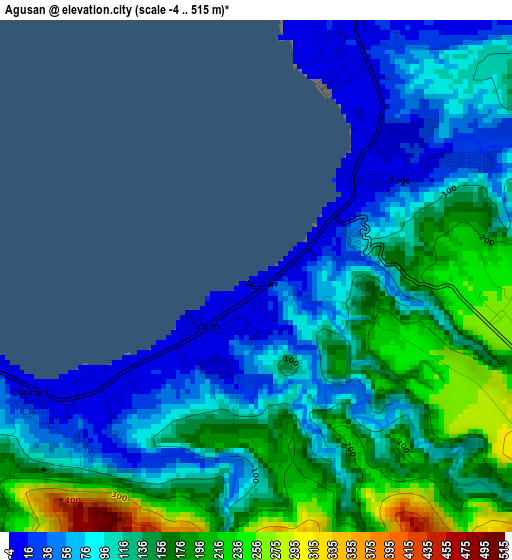
Below is the Elevation map of Agusan, which displays elevation range with different colors. Scale of the first map is from -4 to 515 m (-13 to 1690 ft) with average elevation of 123.8 meters (=406 ft) [note 1]
These maps also provides idea of topography and contour of this city, they are displayed at different zoom levels. More info about maps, scale and edge coordinates you can find below images.
| \ | Map #1 | Map #2 | Topo.Map |
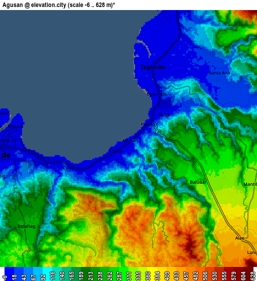
| Scale [m] | -4..515 m | -6..628 m | × |
| Scale [ft] | -13..1690 ft | -20..2060 ft | × |
| Average | 123.8 m = 406 ft | 212.3 m = 697 ft | × |
| Width | 9.67 km = 6 mi | 19.33 km = 12 mi | 309.3 km = 192.2 mi |
| Height | 9.67 km = 6 mi | 19.33 km = 12 mi | 309.3 km = 192.2 mi |
| ↑Max Latitude | 8.534021° | 8.577477° | 9.87874° |
| Latitude at center | 8.49056° | 8.49056° | 8.49056° |
| ↓Min Latitude | 8.447094° | 8.403623° | 7.09734° |
| ← Min Longitude | 124.693275° | 124.649329° | 123.33097° |
| Longitude center | 124.73722° | 124.73722° | 124.73722° |
| →Max Longitude | 124.781165° | 124.825111° | 126.14347° |
Nearby cities:
Cities around Agusan sort by population:
• Cagayan de Oro elevation 8 m
9.9 km,  264°
264°
• Bugo 9 m
3.1 km,  51°
51°
• Tagoloan 15 m
5.8 km,  18°
18°
• Barra 1 m
14.8 km,  278°
278°
• Villanueva 10 m
11.7 km, 21°
• Santa Ana 57 m
5.8 km,  60°
60°
• Alae 420 m
11.1 km,  131°
131°
• Kimaya 181 m
14 km, 53°
• Aplaya 42 m
13.6 km,  14°
14°
• San Martin 13 m
8.7 km,  25°
25°
• Solana 134 m
15.2 km, 13°
• Mambatangan 382 m
12.3 km,  121°
121°
Multilingual:
 En español:
Agusan elevación 0 m.
 En France:
Agusan élévation 0 m.


Sources and notes:
- [note 1] Map square and city borders are not equal. Map elevation data is calculated only from area inside that square.
- [src 1] Elevation data from geonames database provided with same terms of usage.
- [src 2] The elevation map of Agusan is generated using elevation data from NASA's 3 arcsec (90m) resolution SRTM data.
- [src 3] Base (background) map © OpenStreetMap contributors tiles are generated by Geofabrik and OpenTopoMap.
Copyright & License:
This Agusan Elevation Map is licensed under CC BY-SA. You may reuse any part from this page, if you give a proper credit by linking to this URL:
 More info on terms of use page.