Tagoloan elevation
Tagoloan (Northern Mindanao, Province of Misamis Oriental), Philippines elevation is 15 meters and Tagoloan elevation in feet is 49 ft above sea level [src 1]. Tagoloan is a seat of a third-order administrative division (feature code) with elevation that is 73 meters (240 ft) smaller than average city elevation in Philippines.
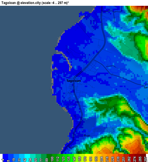
Below is the Elevation map of Tagoloan, which displays elevation range with different colors. Scale of the first map is from -4 to 297 m (-13 to 974 ft) with average elevation of 45.9 meters (=151 ft) [note 1]
These maps also provides idea of topography and contour of this city, they are displayed at different zoom levels. More info about maps, scale and edge coordinates you can find below images.
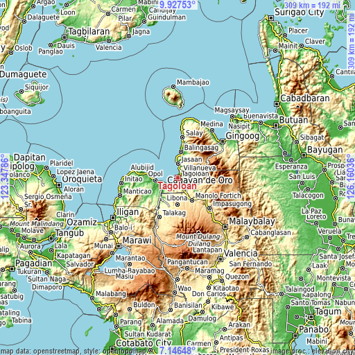
| \ | Map #1 | Map #2 | Topo.Map |
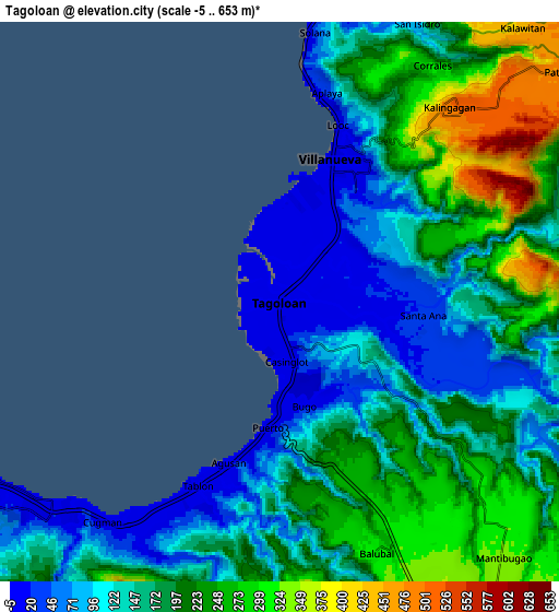
| Scale [m] | -4..297 m | -5..653 m | × |
| Scale [ft] | -13..974 ft | -16..2142 ft | × |
| Average | 45.9 m = 151 ft | 175.8 m = 577 ft | × |
| Width | 9.66 km = 6 mi | 19.33 km = 12 mi | 309.2 km = 192.1 mi |
| Height | 9.66 km = 6 mi | 19.33 km = 12 mi | 309.3 km = 192.2 mi |
| ↑Max Latitude | 8.582996° | 8.626446° | 9.92753° |
| Latitude at center | 8.53954° | 8.53954° | 8.53954° |
| ↓Min Latitude | 8.496079° | 8.452614° | 7.14648° |
| ← Min Longitude | 124.710165° | 124.666219° | 123.34786° |
| Longitude center | 124.75411° | 124.75411° | 124.75411° |
| →Max Longitude | 124.798055° | 124.842001° | 126.16036° |
Nearby cities:
Cities around Tagoloan sort by population:
• Cagayan de Oro elevation 8 m
13.4 km,  241°
241°
• Bugo 9 m
3.5 km,  170°
170°
• Jasaan 31 m
12.7 km,  0°
0°
• Agusan 0 m
5.8 km,  198°
198°
• Villanueva 10 m
6 km,  23°
23°
• Santa Ana 57 m
4.1 km,  128°
128°
• Kimaya 181 m
9.8 km,  73°
73°
• Aplaya 42 m
7.8 km,  11°
11°
• San Martin 13 m
3.1 km,  38°
38°
• Patrocinio 484 m
12.9 km,  51°
51°
• Malitbog 150 m
14.2 km,  92°
92°
• Solana 134 m
9.5 km, 11°
Multilingual:
 En español:
Tagoloan elevación 15 m.
 En France:
Tagoloan élévation 15 m.


Sources and notes:
- [note 1] Map square and city borders are not equal. Map elevation data is calculated only from area inside that square.
- [src 1] Elevation data from geonames database provided with same terms of usage.
- [src 2] The elevation map of Tagoloan is generated using elevation data from NASA's 3 arcsec (90m) resolution SRTM data.
- [src 3] Base (background) map © OpenStreetMap contributors tiles are generated by Geofabrik and OpenTopoMap.
Copyright & License:
This Tagoloan Elevation Map is licensed under CC BY-SA. You may reuse any part from this page, if you give a proper credit by linking to this URL:
 More info on terms of use page.