Alegria elevation
Alegria (Western Visayas, Province of Negros Occidental), Philippines elevation is 283 meters and Alegria elevation in feet is 928 ft above sea level [src 1]. Alegria is a populated place (feature code) with elevation that is 195 meters (640 ft) bigger than average city elevation in Philippines.
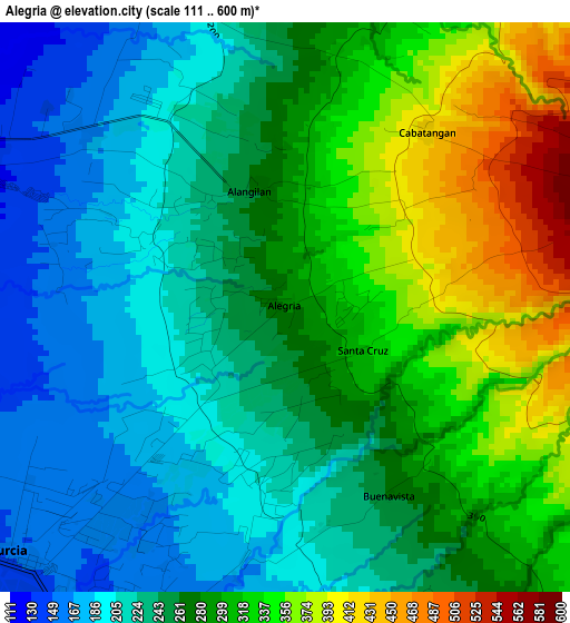
Below is the Elevation map of Alegria, which displays elevation range with different colors. Scale of the first map is from 111 to 600 m (364 to 1969 ft) with average elevation of 269.3 meters (=884 ft) [note 1]
These maps also provides idea of topography and contour of this city, they are displayed at different zoom levels. More info about maps, scale and edge coordinates you can find below images.
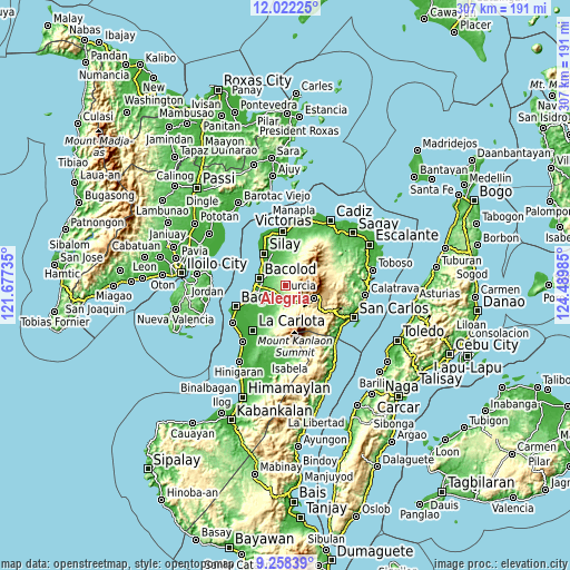
| \ | Map #1 | Topo.Map |
| Scale [m] | 111..600 m | × |
| Scale [ft] | 364..1969 ft | × |
| Average | 269.3 m = 884 ft | × |
| Width | 9.6 km = 6 mi | 307.3 km = 190.9 mi |
| Height | 9.6 km = 6 mi | 307.3 km = 190.9 mi |
| ↑Max Latitude | 10.686636° | 12.02225° |
| Latitude at center | 10.64345° | 10.64345° |
| ↓Min Latitude | 10.600258° | 9.25839° |
| ← Min Longitude | 123.039655° | 121.67735° |
| Longitude center | 123.0836° | 123.0836° |
| →Max Longitude | 123.127545° | 124.48985° |
Nearby cities:
Cities around Alegria sort by population:
• Mansilingan elevation 45 m
11.5 km,  263°
263°
• Murcia 152 m
6.3 km,  227°
227°
• Dos Hermanas 53 m
12.1 km,  335°
335°
• Concepcion 166 m
5.9 km, 335°
• Capitan Ramon 197 m
13.4 km,  14°
14°
• Cansilayan 68 m
11.7 km,  217°
217°
• Hacienda Santa Rosa 169 m
8.1 km,  166°
166°
• San Fernando 160 m
7.4 km,  348°
348°
• Santa Cruz 252 m
1.1 km,  188°
188°
• Buenavista 265 m
3.6 km,  151°
151°
• New Pandanon 190 m
11.9 km,  144°
144°
• San Miguel 158 m
11.7 km,  180°
180°
Multilingual:
 En español:
Alegria elevación 283 m.
 En France:
Alegria élévation 283 m.


Sources and notes:
- [note 1] Map square and city borders are not equal. Map elevation data is calculated only from area inside that square.
- [src 1] Elevation data from geonames database provided with same terms of usage.
- [src 2] The elevation map of Alegria is generated using elevation data from NASA's 3 arcsec (90m) resolution SRTM data.
- [src 3] Base (background) map © OpenStreetMap contributors tiles are generated by Geofabrik and OpenTopoMap.
Copyright & License:
This Alegria Elevation Map is licensed under CC BY-SA. You may reuse any part from this page, if you give a proper credit by linking to this URL:
 More info on terms of use page.