San Fernando elevation
San Fernando (Western Visayas, Province of Negros Occidental), Philippines elevation is 160 meters and San Fernando elevation in feet is 525 ft above sea level [src 1]. San Fernando is a populated place (feature code) with elevation that is 72 meters (236 ft) bigger than average city elevation in Philippines.
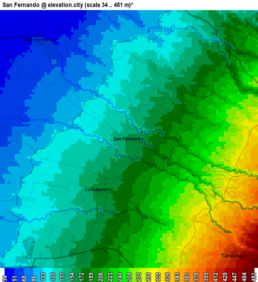
Below is the Elevation map of San Fernando, which displays elevation range with different colors. Scale of the first map is from 34 to 481 m (112 to 1578 ft) with average elevation of 166.1 meters (=545 ft) [note 1]
These maps also provides idea of topography and contour of this city, they are displayed at different zoom levels. More info about maps, scale and edge coordinates you can find below images.
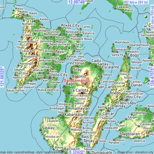
| \ | Map #1 | Topo.Map |
| Scale [m] | 34..481 m | × |
| Scale [ft] | 112..1578 ft | × |
| Average | 166.1 m = 545 ft | × |
| Width | 9.6 km = 6 mi | 307.2 km = 190.9 mi |
| Height | 9.6 km = 6 mi | 307.3 km = 190.9 mi |
| ↑Max Latitude | 10.752177° | 12.08748° |
| Latitude at center | 10.709° | 10.709° |
| ↓Min Latitude | 10.665817° | 9.32422° |
| ← Min Longitude | 123.025555° | 121.66325° |
| Longitude center | 123.0695° | 123.0695° |
| →Max Longitude | 123.113445° | 124.47575° |
Nearby cities:
Cities around San Fernando sort by population:
• Mansilingan elevation 45 m
13.2 km,  228°
228°
• Binonga 15 m
11.9 km,  306°
306°
• Talisay 9 m
11.7 km,  285°
285°
• Murcia 152 m
11.9 km,  194°
194°
• Eustaquio Lopez 28 m
12.7 km,  345°
345°
• Dos Hermanas 53 m
5.1 km,  316°
316°
• Concepcion 166 m
2.1 km,  206°
206°
• Capitan Ramon 197 m
7.5 km,  40°
40°
• Santa Cruz 252 m
8.5 km,  170°
170°
• Alegria 283 m
7.4 km, 168°
• Buenavista 265 m
11 km,  162°
162°
• Imbang 22 m
11.1 km,  331°
331°
Multilingual:
 En español:
San Fernando elevación 160 m.
 En France:
San Fernando élévation 160 m.
 Auf Deutsch:
San Fernando höhe über dem Meeresspiegel ist 160 m.

Sources and notes:
- [note 1] Map square and city borders are not equal. Map elevation data is calculated only from area inside that square.
- [src 1] Elevation data from geonames database provided with same terms of usage.
- [src 2] The elevation map of San Fernando is generated using elevation data from NASA's 3 arcsec (90m) resolution SRTM data.
- [src 3] Base (background) map © OpenStreetMap contributors tiles are generated by Geofabrik and OpenTopoMap.
Copyright & License:
This San Fernando Elevation Map is licensed under CC BY-SA. You may reuse any part from this page, if you give a proper credit by linking to this URL:
 More info on terms of use page.