Bagontapay elevation
Bagontapay (Soccsksargen, Province of Cotabato), Philippines elevation is 32 meters and Bagontapay elevation in feet is 105 ft above sea level [src 1]. Bagontapay is a populated place (feature code) with elevation that is 56 meters (184 ft) smaller than average city elevation in Philippines.
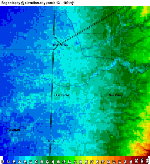
Below is the Elevation map of Bagontapay, which displays elevation range with different colors. Scale of the first map is from 13 to 109 m (43 to 358 ft) with average elevation of 33.1 meters (=109 ft) [note 1]
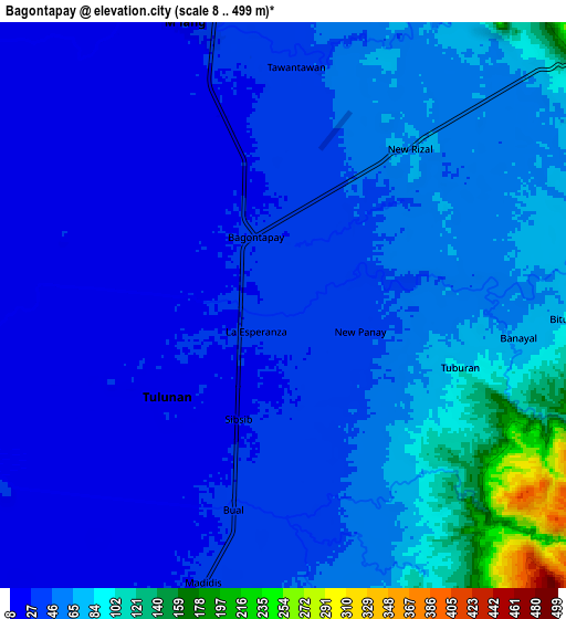
These maps also provides idea of topography and contour of this city, they are displayed at different zoom levels. More info about maps, scale and edge coordinates you can find below images.
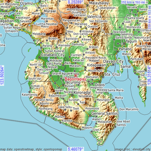
| \ | Map #1 | Map #2 | Topo.Map |
| Scale [m] | 13..109 m | 8..499 m | × |
| Scale [ft] | 43..358 ft | 26..1637 ft | × |
| Average | 33.1 m = 109 ft | 51 m = 167 ft | × |
| Width | 9.7 km = 6 mi | 19.41 km = 12.1 mi | 310.5 km = 192.9 mi |
| Height | 9.7 km = 6 mi | 19.41 km = 12.1 mi | 310.5 km = 192.9 mi |
| ↑Max Latitude | 6.902519° | 6.946144° | 8.25289° |
| Latitude at center | 6.85889° | 6.85889° | 6.85889° |
| ↓Min Latitude | 6.815257° | 6.77162° | 5.46079° |
| ← Min Longitude | 124.864945° | 124.820999° | 123.50264° |
| Longitude center | 124.90889° | 124.90889° | 124.90889° |
| →Max Longitude | 124.952835° | 124.996781° | 126.31514° |
Nearby cities:
Cities around Bagontapay sort by population:
• Buluan elevation 16 m
19.4 km,  217°
217°
• Tulunan 20 m
4.5 km,  232°
232°
• Bialong 25 m
13.7 km,  350°
350°
• Digal 14 m
17.1 km, 226°
• Badak 11 m
20.8 km,  266°
266°
• Columbio 52 m
18.3 km,  170°
170°
• Dunguan 22 m
11.4 km,  332°
332°
• Bual 33 m
7 km,  178°
178°
• Idtig 12 m
16.4 km,  246°
246°
• Katico 23 m
22.4 km,  240°
240°
• Datu Paglas 22 m
12.1 km,  212°
212°
• Minapan 16 m
7.4 km, 228°
Multilingual:
 En español:
Bagontapay elevación 32 m.
 En France:
Bagontapay élévation 32 m.
 Auf Deutsch:
Bagontapay höhe über dem Meeresspiegel ist 32 m.

Sources and notes:
- [note 1] Map square and city borders are not equal. Map elevation data is calculated only from area inside that square.
- [src 1] Elevation data from geonames database provided with same terms of usage.
- [src 2] The elevation map of Bagontapay is generated using elevation data from NASA's 3 arcsec (90m) resolution SRTM data.
- [src 3] Base (background) map © OpenStreetMap contributors tiles are generated by Geofabrik and OpenTopoMap.
Copyright & License:
This Bagontapay Elevation Map is licensed under CC BY-SA. You may reuse any part from this page, if you give a proper credit by linking to this URL:
 More info on terms of use page.