Balogo elevation
Balogo (Central Visayas, Province of Negros Oriental), Philippines elevation is 461 meters and Balogo elevation in feet is 1512 ft above sea level [src 1]. Balogo is a populated place (feature code) with elevation that is 373 meters (1224 ft) bigger than average city elevation in Philippines.
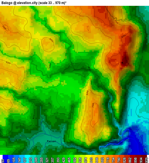
Below is the Elevation map of Balogo, which displays elevation range with different colors. Scale of the first map is from 33 to 970 m (108 to 3182 ft) with average elevation of 485.8 meters (=1594 ft) [note 1]
These maps also provides idea of topography and contour of this city, they are displayed at different zoom levels. More info about maps, scale and edge coordinates you can find below images.
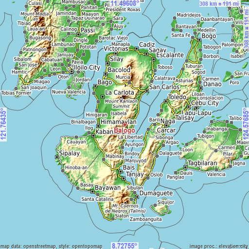
| \ | Map #1 | Topo.Map |
| Scale [m] | 33..970 m | × |
| Scale [ft] | 108..3182 ft | × |
| Average | 485.8 m = 1594 ft | × |
| Width | 9.62 km = 6 mi | 307.8 km = 191.3 mi |
| Height | 9.62 km = 6 mi | 307.9 km = 191.3 mi |
| ↑Max Latitude | 10.158059° | 11.49608° |
| Latitude at center | 10.1148° | 10.1148° |
| ↓Min Latitude | 10.071535° | 8.72755° |
| ← Min Longitude | 123.126655° | 121.76435° |
| Longitude center | 123.1706° | 123.1706° |
| →Max Longitude | 123.214545° | 124.57685° |
Nearby cities:
Cities around Balogo sort by population:
• Tinongan elevation 29 m
18.5 km,  306°
306°
• Guihulñgan 6 m
11.4 km,  86°
86°
• La Libertad 9 m
12 km,  144°
144°
• Buenavista 66 m
8.4 km,  72°
72°
• Basak 9 m
19.4 km,  50°
50°
• Jimalalud 10 m
15.4 km,  167°
167°
• Calamba 14 m
14 km,  61°
61°
• Anopog 627 m
17.4 km,  30°
30°
• Malusay 58 m
11.5 km, 73°
• Cansolungon 74 m
19.3 km,  282°
282°
• Padre Zamora 11 m
10.2 km,  121°
121°
• McKinley 13 m
10.3 km,  109°
109°
Multilingual:
 En español:
Balogo elevación 461 m.
 En France:
Balogo élévation 461 m.


Sources and notes:
- [note 1] Map square and city borders are not equal. Map elevation data is calculated only from area inside that square.
- [src 1] Elevation data from geonames database provided with same terms of usage.
- [src 2] The elevation map of Balogo is generated using elevation data from NASA's 3 arcsec (90m) resolution SRTM data.
- [src 3] Base (background) map © OpenStreetMap contributors tiles are generated by Geofabrik and OpenTopoMap.
Copyright & License:
This Balogo Elevation Map is licensed under CC BY-SA. You may reuse any part from this page, if you give a proper credit by linking to this URL:
 More info on terms of use page.